Savannah/Hilton Head Int’l Prepares to Integrate Drones Into Airport & Airfield Operations
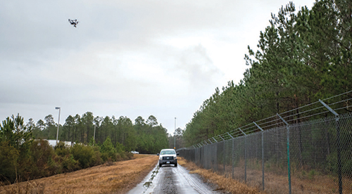
Patrolling the perimeter fence at Savannah/Hilton Head International Airport (SAV) is a difficult task, thanks to about 400 acres of swampland—and the alligators, snakes and other wildlife that live there. But it’s an easy job for a camera-equipped drone. That’s why the Georgia facility is striving to become one of the first commercial airports in the United States to integrate drone flights into some of its routine safety and security operations.
Since mid-2017, SAV officials have been working with Woolpert to develop protocols that will allow unmanned aircraft systems (UAS) to patrol the airport’s 12+ miles of perimeter fencing, assist with wildlife management efforts and perform runway pavement inspections.
Potential perimeter inspection applications are particularly appealing, because approximately 10% of the airport’s fencing crosses through hard-to-access swampland, explains Airfield Operations Manager Edwin Rahn. “There are many areas on the airport grounds that aren’t accessible by foot, vehicle or watercraft—they’re just too swampy,” says Rahn. “We also see drones as a key player in wildlife mitigation. They can fly over those swampy areas and help us see what, if any, wildlife is present and what it’s doing. Are beavers damming up water channels that can create flooding? Are birds nesting in areas where we don’t want them nesting? Drones can help us more safely answer those questions.”
|
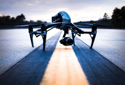
Project: Drone Operations Location: Savannah/Hilton Head (GA) Int’l Airport Missions: Perimeter security, wildlife management, airfield pavement inspections Consultant: Woolpert Contract Cost: About $90,000 Funding: General airport revenue Recommended Equipment: Inspire 2 drone, from DJI, with high-resolution Zenmuse X7 camera Expected Implementation: 2019 Key Benefits: Safer, faster perimeter security & airfield pavement inspections; wildlife detection/hazard mitigation |
 facts&figures
Employees currently use utility terrain vehicles to monitor the perimeter fence and keep tabs on area wildlife, but the tasks can be very time-consuming—especially if a vehicle gets stuck in the mucky swamp. “It’s a safety issue, too,” Rahn points out. “Here in the South, we have snakes, alligators, fire ants and spiders. And if someone doing wildlife mitigation inspections is wearing hip waders and they fill up with water, the person can easily drown.
“But a drone can fly over an area and take a detailed look from the air,” he adds. “Instead of, for instance, taking several hours or even a full day to go in and locate a beaver dam, we can bring back drone footage and analyze it without traipsing around a swamp.”
Facilitating inspection of the airport’s two runways—9,351 feet and 7,002 feet—plus associated taxiways and ramp areas is another possible use that is being considered. Drones can be programmed to fly a precise grid pattern and take high-resolution footage for SAV engineers and managers, explains Rahn. “Then they can view it without ever having to go out there and beat the pavement,” he says. “It’s very interesting stuff.”
Rules & Regs
Thomas Mackie, aviation practice leader and a vice president at Woolpert, considers it part of the company’s job to help SAV and other airports navigate the thicket of FAA rules that regulate drone use.
“We’re taking a crawl, walk and run approach at Savannah,” says Mackie. “Phase one is very heavy on addressing risks and determining applications of the technology—figuring out what are the key aspects that must be considered and addressed, as well as short-listing the drone options.”
The first step includes drafting a Concept of UAS Operations—ConOps, for short. This document addresses a wide range of factors such as flight schedules, risk management considerations and communication protocols. “While all airports have distinct needs and directives, this guidebook illustrates how commercial airports can conceptually go about flying a drone in support of operational needs,” says Mackie.
One significant consideration is coordinating with air traffic control to define acceptable drone operating areas, times and conditions. Developing protocols for emergency response should something go awry during a drone flight is another important precursor, he notes.
Airports also need to determine factors that could have a detrimental impact on drone operations at their specific fields. For example, are there areas where radio frequency interference could affect the control of drones? Are there line-of-sight limitations such as hangars or other buildings that could prevent air traffic controllers from seeing drones?
“Such blind spots (communication or line-of-sight) are a problem…you have to figure out how to mitigate those factors with your flight plans,” Mackie advises.
At SAV, drone flights aren’t expected to last very long, and they’ll occur in small areas, which makes such issues more manageable, he adds.
 Drone operators are required by the FAA to obtain a license, maintain continuous visual contact with their aircraft, and maintain radio communication with air traffic controllers when flying a drone in controlled air space.
Test Flights Completed
Initial drone test flights occurred at SAV in January. Operations were conducted in four different areas of the airport and were pre-arranged with the FAA, Rahn notes.
The verdict: Drones can be used safely and efficiently for routine operational needs such mitigating wildlife hazards and performing daytime perimeter checks. In fact, the value of using drones was underscored when one of the test flights revealed that a fallen tree had broken through the perimeter fence on the swampy north end of the airport. The area is particularly difficult to access on foot or by watercraft, but the drone safely and efficiently collected GPS coordinates of the fallen tree and transmitted real-time imagery of the fence breach, Mackie explains.
Before conducting the test flights, SAV officials used software to establish a geofence—a virtual boundary for the drone that is similar to invisible electric fences that keep pets inside residential yards.
 “The test flights went very well,” Rahn reports. “The drone did exactly what we told it to do, even when we tried to make it cross the geofence.”
Of the many different kinds of drones on the market, Woolpert is recommending a multi-rotor model for the particular applications SAV has in mind. “They can perform vertical takeoffs and landings, so there’s no need for a large area to launch and land,” says Mackie. “That’s important because there always are things like trees, power lines and buildings to consider.”
Getting Specific
Test flights indicated that the Inspire 2 drone, made by DJI, was best suited for SAV’s needs, Mackie reports. The unit weighs 7.58 pounds without extra equipment on board, and its gimbal—the pivot point where a camera can attach—rotates 360 degrees. The drone can accelerate from 0 to 50 mph in just five seconds, with a maximum speed of 58 mph. According to specifications on DJI’s website, the Inspire 2 can fly up to 27 minutes before its two batteries need recharging.
SAV and Woolpert officials also gravitate toward the Inspire 2 because it’s the only drone that can carry a high-resolution X7 color camera, made by Zenmuse. “The X7 brings the shock and awe factor,” Mackie quips. “It offers the highest resolution commercially available for drones. The resolution of the video it takes is so sharp that from 100 feet up, you can read the numbers on a bar code.”
 The camera’s high-resolution capability increases the drone’s ability to operate safely, because it doesn’t have to get as close to objects or areas SAV personnel want to view. This could prove especially valuable for operations in controlled air space. “We can fly farther away from aircraft and still collect data that provides a great service to the airport,” Mackie explains.
The Inspire 2 also features “swappable payload” capability. This would allow SAV personnel to switch, for example, from a thermal camera that detects heat emitted by people or animals to a special multi-spectral camera that can detect objects invisible to human eyes, such as tiny growth on vegetation.
Mackie lauds the DJI drone’s control station software for providing versatile flight planning capabilities. An operator can fly it autonomously by programming a flight plan or fly it manually via a joystick and an iPad. “It really gives the operator a lot of flexibility in terms of flight planning and in overriding the controls if hazardous situations arise,” he comments.
More Planning & Decisions Ahead
The next phase of SAV’s drone implementation program will include flying drones in airport operating areas; obtaining FAA approval; validating that a drone can be used safely to support additional airport missions; helping SAV staffers obtain drone pilot licenses; and refining the systems, sensors, processes and data management techniques to reflect the airport’s needs. Phase three, which Woolpert estimates is about one year away, will focus on acquiring a drone.
According to Mackie, one thing is certain: It’s only a matter of time before drones become more integral to airport operations nationwide. “It’s not even a growing trend. It’s here and now in terms of excitement and enthusiasm,” he says. “It is a very hot topic as airports see that they can use drones for the same applications they’re already being used for outside of airports.”
At SAV, Woolpert is working toward using drones to augment existing operations, rather than just for single missions such as a construction project or pavement study. The company has already performed aeronautical surveys and base mapping for the airport and has loaded that data into an asset management system called Cityworks, from Azteca Systems. Eventually, information gathered by drones will be integrated into the system.
As an example, SAV could use drones to collect data and imagery about airfield pavement conditions, and then create work orders and upload it all into Cityworks. “The additional capability with UAS will not eliminate the human in the loop for airfield operations,” Mackie says. “But it will certainly provide an opportunity to minimize frequency and duration of time spent in safety-critical areas and create valuable geodata as part of the airport’s system of records.”
Rahn also sees vast potential for using drones. “Right now, our planning is in the incipient stages,” he says. “But the sky’s the limit to what drones can do. I believe that the more we use them, the more we’ll see where else we can use them. But you have to crawl before you can walk.”
FREE Whitepaper
Fairbanks International Airport Baggage Transport Conveyor Enhanced With Mod Drive™ System
Airports face a host of unique industry challenges, such as meeting efficiency regulations and seeking out the best maintenance practices to reduce costs and keep operations flowing. In today’s current economic climate, any potential cost savings can go a long way.
In 2019, Alaska’s Fairbanks International Airport (FAI) sought to modernize its equipment and operations. They were dissatisfied with the performance of the gearmotors on their baggage transport conveyors and began searching for new suppliers. Regal approached FAI with a solution that could improve equipment performance and simplify maintenance, with the added benefit of energy cost savings: the Hub City® MOD Drive™ system.
This white paper discusses the hardware deployed, the test results and the annualized expectations for ROI.
Featured Video
Featured Video
Digital Issue:

Connect


Publisher's Blog

# # #

Project Nominations
Know of a project that should be covered in a future issue of Airport Improvement?
Artscapes
")
# # #
# # #
# # #
Airport Industry Headlines
- Phoenix Airport System’s Economic Impact is $44.3 Billion
- Biden-Harris Administration Announces $76 Million in Grants from Bipartisan Infrastructure Law to Modernize Airports, From Runway Improvements to Better Facilities
- Tri-Cities Airport to See Nonstop Service to Los Angeles on Alaska Airlines
- Southwest Airlines to Cease Operations in Syracuse
- ADB SAFEGATE Awarded Contracts for The New Terminal One at JFK Airport
# # #
Airside Projects
- New Apron Lighting Resolves Glaring Issues at Dallas Love Field
- Florida’s Statewide Markings Program Evolves
- Lincoln Airport Takes Creative Route to Adding New Leisure Service
- New Taxiway at Myrtle Beach Int’l Improves Airfield Safety, Frees Space for Terminal Expansion
- Tampa Int’l Plots New Course to Enhance Airfield Safety
Baggage Projects
- Rapidly Growing Volume of Oversized Baggage Prompts System Redesign at Salt Lake City Int’l
- Columbia Metropolitan Upgrades Baggage System and Ticketing Lobby
- Long Beach Airport Adds Permanent Checked Baggage Inspection System and Improves Ticketing Building
- New Concourse at Phoenix Sky Harbor Features Advanced Baggage Handling System
- New Baggage System at Orlando Int’l Features Individual Totes and Upper-Level Claim Area
# # #
Cargo Projects
- Spokane Int’l Builds Rail-Truck Facility on Surplus Land
- Halifax Stanfield Builds Cargo Park With Cold Chain Capabilities
- Extensive Cargo Growth at Cincinnati Int’l Boosts Revenues, Diversifies Business Base
- FedEx Expands at Ontario Int’l to Support Growing E-Commerce Demand
- Winnipeg Int’l Adds Multiuse Facility to Enhance Cargo Operations
Concessions/Retail Projects
# # #
Emergency Operations Projects
- New ARFF Facility Boosts Efficiency, Paves Way for New Terminal at Monterey Regional
- Decatur Airport Builds New Facility for Firefighting and Maintenance Teams
- Naples Airport Recovers After Hurricane Ian’s Saltwater Storm Surge
- Sacramento Int’l Builds Bigger, Better Fire and Rescue Station
- Hybrid Fire Station at San José Int’l Provides Emergency Services for Airport and Surrounding Area
Environment/Sustainability Projects
- Toronto City Airport Leads the Move to Fluorine-Free Firefighting Foam
- New Noise Technology System at Minneapolis-St. Paul Int’l Earns Patent
- Martha’s Vineyard Airport Tests Underground Filtration for PFAS Contamination
- Santa Maria Airport Takes Common Sense Approach to PFAS Testing
- Philadelphia Int’l Follows Envision Program for Major Taxiway Rehab
# # #
Fuel Operations Projects
General Aviation Projects
Ground Support Projects
- Montgomery Regional Leaps Into the Future With Electric Aircraft Chargers
- Exterior Jet Bridge Coating Saves Energy, Increases Passenger Comfort at Harry Reid Int’l
- O’Hare Moves Aircraft Deicing From Gates to High-Tech Centralized Facility
- Ground Power Upgrades in the Works at Newark Int’l
- Long Beach Airport & Airline Partners Phase Out Fossil Fuels for Ground Support Equipment
# # #
Hangar Projects
IT/Communications Projects
- Hawaii Provides State-Owned Airports with Online Platform for Environmental Systems Management
- Website Platform Helps Airports Attract More Customers
- Virtual Ramp System at Kansas City Int’l Provides 360-Degree View of Airfield
- Interactive Web Page Offers Planning Tools for Memphis Int’l Travelers
- Seattle-Tacoma Int’l Invests in Data Management Upgrade
Landside Development Projects
Operations Projects
- Safety Management Systems: Lessons from the Airline Sector
- Historic Wildfires Prompt Kelowna Int’l to Move Commercial Flights From Day to Night
- Terminal Expansion at Kansas City Int’l Prompts New Snow Removal Strategy and Equipment
- New Glycol Recycling Facility at Syracuse Hancock Int’l Produces Deicing Fluid Certified for Reuse
- Drones and Virtual Reality Speed Control Tower Siting at Boulder City Municipal
Parking Projects
- Moving Walkways Replace Decades-Old Monorail at Tampa Int’l
- Sarasota-Bradenton Int’l Adds New Cellphone Lot With Improved Amenities
- Flagstaff Pulliam Implements Paid Parking Program
- New 7-Level Garage Increases Parking Capacity and Convenience for Customers
- Regina Int’l Optimizes Parking with 24/7 Call Center and On-site Customer Service Reps
Passenger Transport Projects
- Plane Train Extension is on Track for 2025 Delivery at Atlanta Int’l
- “Wingless Travel” Takes Flight at Regional Airports
- Inductive Charging for Electric Shuttles
- Winnipeg Int’l Launches Self-Driving Wheelchair Service
- Long-Awaited Rail Extension Is Just the Ticket to Spur Growth at Washington Dulles
Runway/Ramp Projects
- Punta Gorda Closes Runway, Powers Through Rebuild Project
- Vancouver Int’l Turns Untimely Winter Storms Into Opportunity for Improvement
- Airports Apply Heavy Surface Treatment to Increase Service Life of Asphalt Runways
- Round-the-Clock Work Helps Cheyenne Regional Finish Paving Project On Time
- Finish Line in Sight at St. Louis Lambert Int’l
Security Projects
- Dallas Fort Worth Int’l Bolsters Employee Security Screening Program
- Denver Int’l Completes State-of-the-Art West Security Checkpoint
- Harry Reid Int’l Tests Self-Service Checkpoint
- Automated Exit Safeguards and Welcomes Passengers Arriving at Oakland Int’l
- Miami Int’l Tests Perimeter Intrusion Detection and Deterrence Technologies
Terminal Projects
- New Satellite Concourse Provides Efficient Gate Expansion at Nashville Int’l
- Phoenix-Mesa Gateway Completes Five-Gate Addition
- New Outdoor Deck Relieves Passenger Congestion at Charlottetown Airport
- Terminal Modernization at Boston Logan Has Passengers and Locals Seeing Red, But in a Good Way
- Massive Restroom Renovations in Progress at Miami Int’l
# # #
# # #