Tulsa International Airport (TUL) is leveraging aerial drones to take its inspections and maintenance to new heights of effectiveness, efficiency and safety.
The Oklahoma airport has invested nearly $31,000 to purchase four drones since early 2018 and is still discovering new uses for them. Trained operators fly the remote-controlled units to inspect airfield pavement, perimeter fencing and facility rooftops. Other missions include land assessments, wildlife surveys and security audits.
Last May, TUL deployed one of its drones to livestream a training exercise that simulated an airplane crash with the added complication of a train carrying hazardous materials near the airport perimeter. This allowed personnel at the FAA Southwest Regional Office in Fort Worth to watch crews from the airport and several local agencies responding to the mock accident in real-time—a first for the FAA office and airports across the region.
| facts&figures
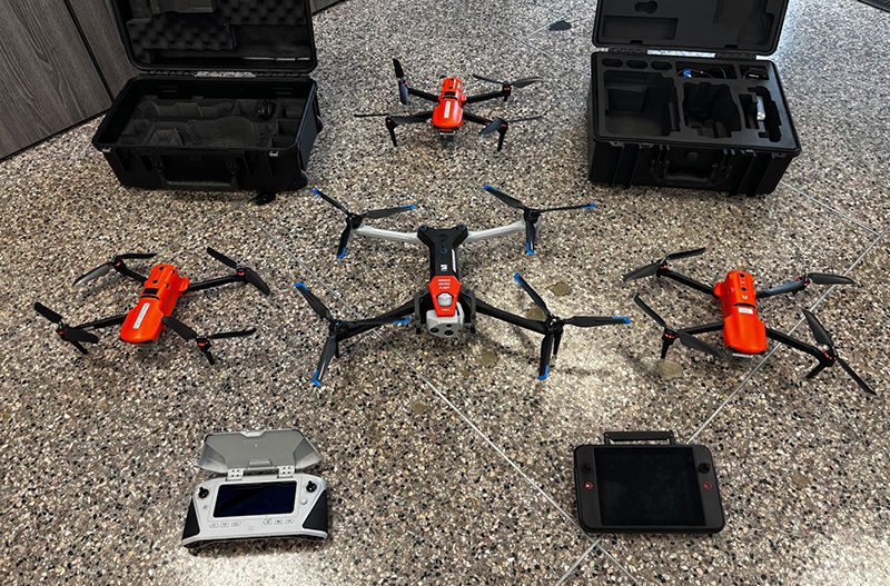
Project: Aerial Drone Program Location: Tulsa Int’l Airport, in OK Drone Missions: Inspecting airfield pavement, facility roofs & perimeter fences; performing wildlife surveys; monitoring progress of infrastructure projects; completing security audits; sending real-time footage of emergency response drill to regional FAA office Cost: Nearly $31,000 for 4 units Funding: Airport revenue Drone Manufacturers: Autel Robotics; Skydio Inc. Capabilities: Photo, video & thermal imaging; telephoto & wide-angle views Requirements: Operator’s license; FAA certificate of waiver Approved Operators: 6 Program Timeline: Early 2022-present Key Benefits: Safer rooftop & airfield inspections; ability to access hard-to-reach areas of perimeter fences; detecting air leaks from facilities; freeing employees to perform other tasks |
“I’m surprised at the number of ways we’ve found to use the drones,” says Michael Dahl, airfield operations agent and unmanned aerial system coordinator. “They’ve been really beneficial. Our drone program has really advanced and grown during the last two years.”
Cole Brown, director of Operations at TUL, is absolutely amazed at the drones’ capabilities. “The sky is the limit for what you can do with drones at an airport,” he says. “They’ve proven to be more useful than
I ever imagined.”
Three of the drones TUL uses were manufactured by Autel Robotics: an EVO II Pro 640T that cost about $4,600 when it was purchased in late 2023 and two earlier EVO II Pro models that cost approximately $2,700 and $3,400 (the latter is equipped with a thermal camera).
The fourth unit, an X10 model from Skydio Inc., was purchased this July for $20,000. It was more expensive because it has advanced features, including regular and thermal-imaging cameras. Dahl notes that having several capabilities in the same unit increases efficiency because operators don’t need to make separate flights to achieve multiple missions.
Program Takes Flight
The airport’s current drone program began in 2022, when a couple of Operations agents decided to used two drones, purchased around 2018, for more than just taking photos. Then Dahl took over the program and completely revamped it.
“I started thinking about how we could utilize them to make our jobs easier,” he recalls. “Over time, we’ve looked at what we do and integrated the drones into those operations whenever possible.”
After obtaining a commercial operator’s license and an FAA certificate of waiver that allows certain kinds of drone flights that would otherwise be prohibited, Dahl first used the drones for airfield pavement inspections, supplementing the FAA-required inspections performed daily by an agent in a pickup truck.
“The perspective from 50 to 75 feet up is a lot different, as you can imagine,” Dahl explains. “You see things you otherwise might not see.”
Drone operators also can record photos and videos during flights. Comparing current images to those taken, say, one year ago can reveal progressive pavement deterioration that otherwise might go undetected, Dahl notes.
Other Applications
The drone program eventually expanded to include tasks such as wildlife surveys. This allows the Operations staff to be more proactive than reactive about deer, coyotes, birds, etc.
“By using the thermal camera, we’ve spotted wildlife close to the airfield that we otherwise wouldn’t have seen because it was dark,” Brown points out. “We’ve also spotted people stealing copper at off-airport properties.”
 The airport also uses drones with thermal cameras to inspect the rooftops of hangars, the terminal and other structures. The cameras detect heat loss, allowing crews to make energy-saving repairs.
The Engineering Department recently requested drone flights to help monitor progress on two construction projects: a taller air traffic control tower and an updated International Customs Facility. The airport expects to complete the approximately 45,000-square-foot, $41 million Customs facility later this year. The roughly $112 million, 257-foot-tall control tower is scheduled to be completely operational in early 2027. The contractor building the control tower requested daily drone flights. It reviews photos taken during them to identify and address safety infractions.
The drones periodically take videos of both projects to update board trustees at the Tulsa Airports Improvement Trust, which manages and operates the city-owned airport.
Eyes in the Sky
Dahl also deploys drones to perform security audits throughout the airfield, including the cargo ramp used by global shippers such as DHL and UPS. Delivery trucks are required to enter and leave this area one at a time, with gates at the security checkpoint closing behind each vehicle before another one passes through.
“We can fly a drone and watch to be sure they’re using proper security measures,” Dahl explains.
Additionally, the aerial units allow Operations staff to examine areas of the airport that are inaccessible by pickup truck during bad weather, such as portions of the perimeter fence.
 “We can fly a drone out there and find things like an animal dig-under or downed barbed wire,” he explains.
To maximize the return on TUL’s investment, any airport stakeholder can request a drone flight by filling out an online form. “If we can accommodate a request, we make it happen,” Dahl says. “We’re leveraging high-resolution drone photos and video footage to help our director of Real Estate and Business Development promote and share information about the more than 700 acres of available airport land with prospective companies. We also use the drones to create engaging content for the Marketing team to share on social media.
“Our goal is to utilize the drones as much as possible to support a wide range of airport initiatives.”
The Operations Department keeps a log of all drone flights so officials know the type and date of inspections, as well as how many flight hours operators are compiling. Aside from Dahl, five other Airfield Operations agents with operator’s licenses fly the equipment, and have logged about 780 hours of flight time since 2022.
Learning Curve
The drones are operated from a handheld control tablet equipped with a joystick and color monitor. Dahl, who taught himself to fly them, describes TUL’s units as easy to operate. That said, he estimates that it takes 80 to 100 hours to get fully comfortable maneuvering the drones and maximizing their capabilities.
“It takes some time to learn how to fly them, for sure,” he reflects.
The drone operators at TUL are expected to log at least eight hours of flight time each month to keep their skills sharp.
They aren’t allowed to operate drones more than 250 feet above ground level, and are required to maintain contact with the air traffic control tower. Furthermore, drones aren’t allowed to fly over an active movement area unless it’s closed, which requires a NOTAM (Notice to Airmen).
“We have to tell the air traffic control tower where we’re going to fly, how high and for how long,” Dahl explains. “If it impacts air traffic, they’ll ask us to do it later. But most of the time, if we aren’t in any approaches or departures for active runways, they have no problem with us putting up drones.”
Due to their cost, TUL used a competitive bid process to purchase the drones. Hedging against a potential federal ban on using drones built in China, the airport specifically selected a brand made in the United States for its latest acquisition.
The X10 from Skydio is also the largest of the airport’s four drones. It weighs about 4½ pounds with a battery on board and is approximately 5½ inches tall and 25½ inches long. The wingspan is 31 inches, though the wings fold to reduce the amount of space needed for storage.
Top horizontal speed for the X10 is 45 miles per hour and maximum flight time is 40 minutes.
The airport continues to find new uses for its four drones.
The cameras include gee-whiz features such as a telephoto lens that allows operators to read license plates from 800 feet above ground. In addition, the thermal camera can detect a person on a rooftop in complete darkness and can even reveal surface temperature differences even on very hot days, according to the Skydio website.
Improving Operational Efficiency
A precise return on investment for the drones is difficult to quantify. But Brown says there is no doubt they’re helping TUL save money by reducing expenses. For example, the airport installed additional insulation in buildings that drone photos showed were leaking heated and conditioned air. Logically, that will translate into lower utility bills.
“We can’t see heat or cool-air loss with our eyes, but the drones’ thermal cameras can show us where it’s occurring,” Brown remarks.
The drones also improve productivity by performing tasks usually handled by employees. That gives them time to do other work, he adds.
Workplace safety is another consideration. “We don’t have to put employees up on a roof unless it’s absolutely necessary,” Brown explains. “So there’s a safety benefit, too.”
Practice Makes Perfect
Dahl encourages airports interested in launching their own drone programs to provide as much detail as possible when applying for an FAA certificate of waiver.
Beyond that, he recommends a lot of practice. “Get out there and log flight hours and get a little better every day,” he advises.
To that end, Dahl invites personnel from other airports to shadow TUL’s experienced drone operators. “They’re more than welcome to come and see what we do,” he says.
Brown says it’s important to support employees like Dahl who are passionate about the evolving aerial technology and interested in creating a drone program.
“We do whatever we can to provide the resources needed,” he says. “You have to trust that your people will utilize the resources you make available to them to the best of their ability.”
Endless Possibilities
Overall, Dahl says drones are helping TUL Operations employees do their jobs better. “They provide us with different perspectives that enhance our capabilities, instead of just doing things like we have for decades,” he explains. “They reflect how this industry is innovating every day.”
Looking ahead, Dahl has been talking to personnel at a Canadian company called Niricson about drone-compatible technology that can identify pavement defects not visible from above. “It can detect cracks under the pavement and create a three-dimensional model of a runway, for example,” he says. “Airports could save a lot of money by nipping problems in the bud.
“It’s just another example of the endless possibilities for drone usage,” Dahl continues. “I think we’re just scratching the surface of what they can do.”