TravelPulse magazine recently named Jackson-Medgar Wiley Evers International (JAN) Mississippi’s best airport in 2018; but management is not taking the title for granted.
TravelPulse magazine recently named Jackson-Medgar Wiley Evers International (JAN) Mississippi’s best airport in 2018; but management is not taking the title for granted.
As passenger traffic increases and new service is added, JAN officials continuously look for ways to offer a premium passenger experience. They recognize that more flights and passengers can increase congestion and lead to longer-than-acceptable wait times at security checkpoints. So JAN officials looked for a way to manage the situation—before continued growth could negatively impact the passenger experience.
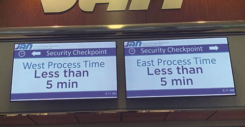
Specifically, JAN wanted to measure checkpoint queuing and processing times, and then share information with travelers to help reduce stress about making it to their gates on time. Research led the airport to iQueue analytics service, by iinside and Infax. JAN’s new system automates operational intelligence about passenger queuing at TSA checkpoints and continuously informs travelers of expected wait times.
|
Project: Checkpoint Queue Tracking Location: Jackson-Medgar Wiley Evers Int’l Airport 2019 Passenger Volume: 942,375 Video Analytics Software: Infax Inc. Sensor Technology: iinside Key Benefits: Wait time estimates reduce stress for passengers; real-time queue data helps TSA adjust staffing levels to fluctuating volume Cost: Airport pays a monthly fee for queue monitoring technology. Fee is based on number of sensors & authorized users. |
 facts&figures
“We chose this system because we wanted to improve the passenger experience,” says Bryan Helaire, director of information technology at Jackson Municipal Airport Authority. “If we could improve our understanding of passenger tendencies arriving at security checkpoints, we could properly plan staffing at peak times, schedule maintenance windows and future terminal development/capital enhancements.”
The system forecasts security checkpoint wait times and estimates the time it will take passengers to get to specific gates using TRAX video analytics from Infax. The company uses queue data, flight volume data and TSA staffing models to project wait times within five minutes.
“The accurate data allows us to disseminate information to passengers so they can plan accordingly, whether viewing the information on our website or on monitors throughout the terminal,” Helaire explains. “We also share metrics with our business partners, TSA, the airlines, etc. Together, we are more conscious about wait times and how we can collectively foster a premium experience for our customers.”
 Getting real-time information helps TSA adjust staffing as security lines lengthen and subside. And, the system’s historical information helps officials plan ahead for peak travel days and times. “We can assess historical incidents, events or out-of-the-norm peaks, and continually improve our processes,” Helaire notes.
LiDAR Makes the Difference
While most queue management systems rely on Wi-Fi and Bluetooth technology, the system at JAN uses LiDAR, which measures distance to a target by illuminating it with laser light and measuring the reflected light with a sensor.
Initially, Infax tried using a Wi-Fi and Bluetooth system at JAN, but problems arose when crews began installing equipment at checkpoints. “The sensors were picking up devices outside of the queuing area, causing the data to be inaccurate,” explains Celso Rodriguez, director of business development, Digital Signage at Infax. “We tried to reduce the sensors’ range to improve accuracy, but they were still not as accurate as we wanted. We tried several sensors, and there was always a problem. Either they weren’t picking up enough devices, or they were picking up too many.”
So Infax reached out to iinside, a California company that provides indoor motion analytics to airports. The team from iinside suggested using LiDAR, and the two companies merged their technologies. Crews installed LiDAR sensors that tied into JAN’s video analytics sensors via a simple application program interface connection.
 “Our test showed the LiDAR sensors worked better than Bluetooth,” says Rodriguez. “From that point on, we’ve used LiDAR—not just at Jackson Medgar, but at other airports as well.”
After testing the technology at JAN, installation took a few days. Infax ran power via POE+ cable to three LiDAR sensors installed on the walls in the two security checkpoints. Cabling was already in place, because the airport’s security cameras connect to it.
“It was a typical IT installation, involving a PC, server, network security, power prep and configurations,” says Helaire. “We then had calibration sessions with Operations, Customer Service and TSA to make sure our reporting captured the right data.”
Sam Kamel, chief executive officer of iinside, was not surprised that LiDAR provided the accuracy JAN needed. “Bluetooth has great capabilities, but it doesn’t offer the precision of LiDAR,” explains Kamel. “LiDAR has to be precise. Autonomous vehicles use it to keep track of kids, dogs and other objects, so they can navigate around them.”
In contrast, Bluetooth/Wi-Fi queue management systems depend on mobile phones. Kamel explains that every mobile phone has three antennas: one for calling/texting, one for Wi-Fi and one for Bluetooth. To calculate queue wait times, Bluetooth sensors pick up radio frequency signals from Bluetooth antennas on passengers’ phones as they pass by.
 “When we put Bluetooth sensors in the perimeter of a space, we can triangulate and approximate each device’s position,” he continues. “We can listen to the signature coming from a device and determine it’s on a person and moving through space. This passive sensor technology keeps track of how many devices are in an area and uses that information to calculate queue wait times.”
Kamel emphasizes that Bluetooth sensors are accurate to within 10 to 20 feet, but LiDAR sensors are accurate within an inch.
“LiDAR is active tracking technology that uses safe, invisible laser beams to detect objects in motion and at rest,” he explains. As a result, LiDAR can give airport operators 360-degree views of their facilities and monitor the flow of passengers in real-time.
Infax mounted LiDAR sensors that are about the size of one soft drink can in three locations at JAN. Each sensor spins and fires eight beams of laser light. When the beams bounce off people, luggage and anything else moving in the space, the sensors measure how long it takes for the light to return to them and uses the data to create a point cloud, or three-dimensional representation, of the light. The representation provides actionable intelligence about the area being scanned.
At JAN, LiDAR sensors from iinside determine the distance, volume and reflectivity of an object, and Infax’s analytics software decides whether it’s a person to count or an object to dismiss. Once the system identifies objects as people, it tracks them as they move through the queue.
“It’s a great system with high precision, because we can now track everybody,” says Kamel. “Unlike Wi-Fi and Bluetooth, you are not plus or minus 10 to 20 feet in terms of location accuracy. You can tell who really is in the queue.”
The system also leverages machine learning to become smarter over time. The LiDAR sensors learn to better evaluate passenger counts and patterns, and the analytics software learns to better understand and predict actual queue times. “For example, the system learns that if a queue has 35 people in it and is moving at X speed, the projected wait time will be Y,” Kamel explains. “Machine learning continually improves the accuracy of the calculations.”
Through machine learning, the system learns queue patterns, too. When the area near the checkpoint is crowded, the software determines whether a person is in the queue or standing next to it. “The system gets smarter and can tell that there are 45 people standing in the defined queue area and 30 standing in the corridor,” Kamel says.
 LiDAR sensors from iinside use laser beams to detect objects in the terminal; software from Infax decides whether they are people to count or objects to disregard. |
Helaire and other airport officials are impressed with the system’s capabilities. “Using LiDAR increases the accuracy of our collected data,” Helaire comments. “Other solutions provide a sample of data, whereas the motion analytics tool we’re using provides a continuous stream of information for operations and passengers. The reporting provides us with a better depiction of what’s happening in our facilities.”
Importantly, the LiDAR-based iQueue analytics service safeguards passenger identities by providing a bird’s-eye/top-down view of people moving through the checkpoint. Other queuing management systems scan faces, says Kamel, noting that some U.S. municipalities ban facial recognition technology and other identification technologies within their city limits.
“Some systems use cameras to do what we do, but the cameras see your face and can track individual identity,” he relates. “You can put controls and protections around that, but it’s never perfect. Our LiDAR-based solution shows the form of a human being, but the resolution doesn’t allow us to understand if it’s a male or a female, an adult or a child.”
LiDAR systems also require airports to mount less equipment in their terminals. The system at JAN includes three sensors to cover two security checkpoints. Kamel notes that a camera-based system would need up to 20 times more units to provide the same coverage.
Monitoring the Results
Infax provides the business intelligence platform that allows JAN officials to view real-time and historic data about checkpoint wait times. In addition, its TRAX Queue Management software automatically calculates and displays estimated wait times to passengers via the airport website and monitors at security queue entrances.
The dashboard allows airport officials to view real-time queue data and pull up specific video analytics sensors to observe the lines. When they confirm that a backup is occurring or brewing, they can ask TSA to open another line or make other changes to speed up the queue. They also can use the dashboard to analyze historical data and glean information about peak times and slow periods. Using the same data, JAN and TSA can work together to optimize staffing.
“As the airport works harder and faster to do more, this system helps them understand what’s going on,” summarizes Kamel. “They can change staffing when there’s an immediate need, or use the data to be more efficient or ramp up staffing during busy times.”
The dashboard allows authorized airport personnel to produce customized reports. For instance, they can compare throughput at various checkpoint lines, or run data about the volume of passengers screened and staff on duty at peak hours.
Infax trained Helaire, TSA leadership and security personnel to use the queuing software, and will provide more training as personnel changes occur.
Future Applications
Helaire notes that JAN may eventually use LiDAR technology in other areas of the airport. For instance, tracking passenger traffic in concessions areas could help retail shops and food/beverage vendors staff up for peak times. Data about passenger flow into the baggage claim area could be used to alert taxis and shuttles when customers will be ready for rides.
“We are still exploring our options as we look at every angle to provide a premier experience for our customers,” says Helaire. “Innovative tools like this can go a long way. They are low-maintenance, and all you need is connectivity and line of sight. The possibilities are endless.”