For years, airport operators categorically derided drones as a safety risk and general nuisance. Now, many are putting them to work for security surveillance, wildlife management and other operation-enhancing purposes.
For years, airport operators categorically derided drones as a safety risk and general nuisance. Now, many are putting them to work for security surveillance, wildlife management and other operation-enhancing purposes.
Erik Nielsen Whitehorse International (YXY), in Yukon, Canada, embraced the technology for airfield surveys.
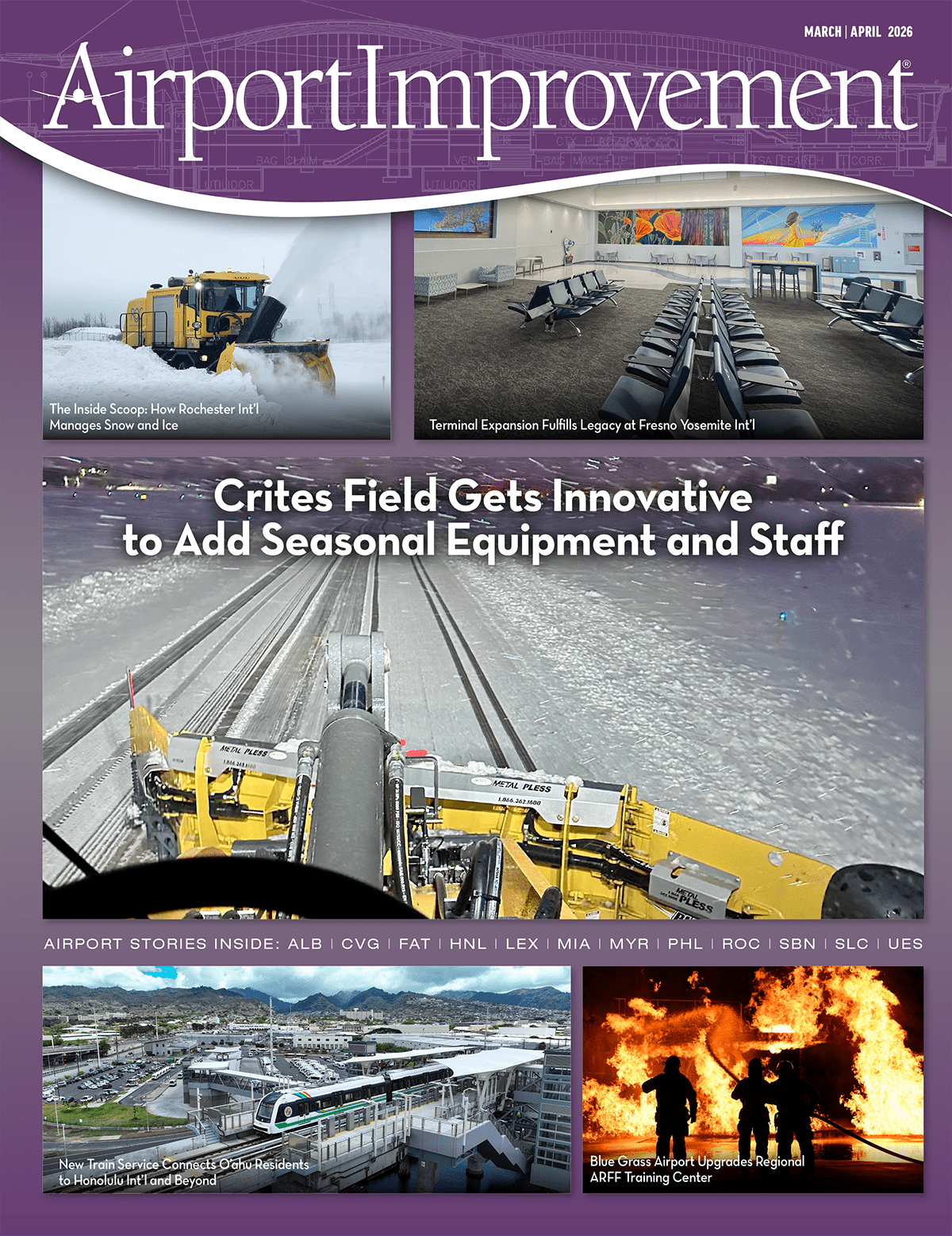
Last July, two small drones were used at YXY to collect images for a detailed runway markings assessment, obstacle limitation surface surveys and runway drainage analysis. The flights took about five days, and the project cost approximately $45,000.
|
Project: Airfield Drone Surveys Location: Erik Nielsen Whitehorse Int’l Airport, Yukon Areas Surveyed: Airfield markings, surface obstacles, airfield drainage Image/Data Collection: 5 days (individual flights took about 25 min.) Approximate Cost: $45,000 Drone Supplier/Operator: Aerium Analytics Models Used: Microdrone mdLiDAR 1000; Sensefly eBee Plus Key Benefits: Reduced downtime for airfield inspections; increased accuracy & amount of data collected |
 facts&figures
“We were very pleased with the results,” reports Airport Manager Robert Manlig. “The data we received will help us continue to maintain regulatory compliance, and will help us plan future improvements of our runways and taxiways.”
The drones were supplied and operated by Aerium Analytics, based in Calgary, AB. Several weeks of planning, however, were needed before they were used on-site at YXY.
Manlig first engaged with Aerium at the 2019 Airports Canada Conference in Kelowna, BC. “They gave us an impressive demonstration, showing us how drones were used at Edmonton Airport as well as a few other facilities. It became readily apparent that there were several possible uses for them at our airfield,” he says.
YXY‘s footprint is fairly straightforward. It has one main runway that is 9,500 feet long, plus a shorter parallel runway and a cross runway. Year-round commercial service is provided by Air North—its main carrier—and Air Canada. Condor and WestJet provide seasonal service. Commercial flights comprise 60% of operations; general aviation and military aircraft comprise the other 40%.
After discussions with Aerium, airport management requested drone surveys of all airfield markings, potential surface obstacles and drainage areas. The drone flights were scheduled for July, when the weather was most likely to cooperate.
Manlig notes that the project required detailed coordination. “We first had to give the drone operators special access to the airfield. Each day, one of our employees escorted them to the launch area,” he explains. “We also gave them the schedule of regularly scheduled commercial flights. In addition, we made sure they were in constant touch with the control tower. In most cases, they had 30 minutes to an hour to fly the drones before the next flight would arrive or take off.”
The Aerium team divided each runway and taxiway surface into sectors, and each flight covered a specific sector point. Individual drone flights lasted about 25 minutes, and the entire image/data collection effort took about five days.
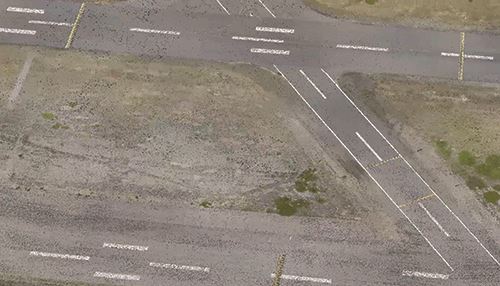
The drones used Light Detection Ranging (LiDAR) or standard red, green, blue (RGB) scans to analyze paint markings, identify potential obstacle limitation surface hazards and survey overall drainage. Airport management received nearly instant feedback throughout the drone flights via a monitor stationed on the ground. The airport also received a complete package of digital scans a few weeks later.
 The scans showed slight imperfections on some of the airfield markings. “We were able to get to work late last summer and this past fall to improve many of those things,” says Manlig. “We still have some work to do this spring.”
The obstacle limitation surface scans revealed that some of the tree lines on both ends of the main runway were a bit higher than regulations allowed. “That detailed data showed us exactly which trees had to be trimmed, and we showed those scans to a local tree-cutting service when they did the cutting. Some of the trees at both ends had to be reduced 10 to 15 feet,” Manlig says.
Mission Details
One of the drones used at YXY (a Microdrone mdLiDAR 1000) was approximately 4 feet wide, 2 feet high and weighed about 13 pounds. The other, a Sensefly eBee Plus, was even smaller (43-inch wingspan, 6 inches high, 2.4 pounds weight). Aerium shipped the units to the airport and provided personnel to operate them.
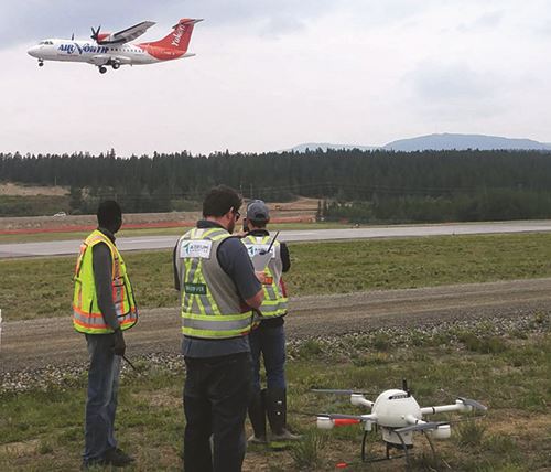
One of the main objectives was to gather images for an airfield markings assessment. Brandon Southgate, a remote sensing and geomatic specialist for Aerium, says that this is a fairly common airport use for drones. The aerial images they collect help airfield maintenance crews pinpoint paint that has faded or is peeling off, markings in the wrong areas, and old markings that were not completely removed.
“Our drones help airports comply with Canada’s TP312 standard, which is similar to Part 139 requirements issued by the FAA,” says Southgate.
Most drones used at airports fly about 150 feet high, he continues. “The drones used at Whitehorse flew at around that height, which is standard for the types of imagery the airport requested,” says Southgate. “For some types of imagery, they can go as high as 400 feet, which is the maximum allowed at most airports.”
The drones used at YXY also measured and scanned potential obstacles. “Our clients often request this service, because of the variety of potential hazards near and on the airfield,” states Lina Kunina, media and marketing coordinator for Aerium. “Common obstacles include hills, tree lines, houses, hills, office buildings, power lines and cellphone towers.”
Beyond gathering information about obstructions and airfield markings, drones have other applications at airports. Some use them for perimeter security or to track wildlife. Kunina notes that drones are also effective for spotting foreign object debris, gathering data for pavement condition indexing or runway displacement analysis, and inspecting perimeter fences and rooftops.
After data is collected, it is colorized and sent to clients digitally. Because the file sizes are large, Kunina advises airports to verify that their equipment and software are compatible, and can handle the volume of data embedded in the scans. “We had a bit of a problem at Whitehorse when we sent just one large file, but then we simply divided it into smaller files. That worked fine,” she adds.
Manlig describes YXY’s drone project as a positive experience and is inclined to use the technology again in the future. “Before this summer, though, we want to make sure we follow up and implement the changes that last year’s drone survey indicated,” he says. “In the future, I am sure we will use them for other projects.”
The drones captured images and data for a runway markings assessment and other airfield surveys:
Other Tech-Forward Projects
Besides using drones, YXY embraces technology in other areas, too. For example, its windsocks are solar-powered. “We can do that because in the summer, we get 23 hours of daylight, and can store energy for the rest of the year,” Manlig explains.
The airport also uses portable lighting to save energy. “We use those on a case-by-case basis; they are used primarily on our secondary runway (14L-32R),” he says.
YXY recently purchased new precision approach path indicators with LED. However, due to the area’s short construction season, crews will wait until this summer to install them.