As U.S. airports prepare to turn the corner on the pandemic and the harsh winter of 2020-2021, some still face a significant long-term challenge: the rise in sea levels resulting from climate change. Although the biggest risk is to airports located along the Atlantic, Pacific and Gulf coasts, experts predict secondary effects for inland airports as well.
As U.S. airports prepare to turn the corner on the pandemic and the harsh winter of 2020-2021, some still face a significant long-term challenge: the rise in sea levels resulting from climate change. Although the biggest risk is to airports located along the Atlantic, Pacific and Gulf coasts, experts predict secondary effects for inland airports as well.
According to the 2017 National Climate Assessment, 13 of the nation’s 47 largest airports are located on coasts and have at least one runway with an elevation within reach of moderate to high storm surge—within 12 feet of current sea levels. (See Page 83 for a list of airports in this category.) Naturally, levels of vulnerability vary with elevation and water level projections for coming decades. The 2017 National Climate Assessment is a federal report under the auspices of the U.S. Global Change Research Program, an initiative by 13 federal agencies, including the U.S. departments of Transportation, Commerce, Defense and the U.S. Environmental Protection Agency.
In addition to sea level issues, climate change also presents challenges associated with higher temperatures and more intense storms, including rain events with river flooding. Concerns about high temperatures prompted the cancellation of some flights at Phoenix Sky Harbor International Airport (PHX) when temperatures reached 118 degrees Fahrenheit during a heat wave there in June 2017. Such extremely hot temperatures can prove dangerous for workers, and may exceed the operating limits of some aircraft.
|
facts&figures
Location: San Francisco Int’l Airport Proposed Project: Shoreline Protection Program Est. Cost: $587 million Expected Funding Sources: Bonds; airline fees Size/Scope: New steel & concrete seawall to add height & storm surge protection Est. Construction: 2025-2035 Status: Completion & release of Environmental Impact Report targeted for 2021 Report Consultant: Environmental Science Associates
Location: Philadelphia Int’l Airport Projects Include: Using climate-resistant materials in construction & renovation projects; studies of long-term risks & responses; incorporating climate-resilient design standards in future construction work & master planning Size/Scope: Steps include flood barriers; construction upgrades redundant IT & communication systems; various plans & assessments Climate Adaptation & Resiliency Plan: $200,000 Climate Vulnerability Assessment: $50,000 Plan & Assessment Consultant: VHB |
 Issue: Rising Sea Level
 Issue: Rising Sea Level
The cancellations at PHX were due to a lack of airliner performance charts for temperatures that high, explains Heather Shelbrack, public information manager for the City of Phoenix Aviation Department, which owns and operates the airport. “Sky Harbor is well prepared for Arizona summers,” adds Shelbrack. For instance, during extreme heat, PHX schedules time-sensitive outdoor work at night, and pumps air co nditioning into underground manholes to help protect airfield electrical workers.
Of course, rising sea levels and other signs of climate change are not exclusively an American problem. In fact, “Coastal Airports and Rising Sea Levels,” in the September 2020 issue of the Journal of Coastal Research, points out that because “most of the world’s major cities are located along coastlines…their large international airports are typically built either very close to sea level or on filled shallow coastal waters.”
More intense and frequent storms caused by climate change could prove especially problematic for such airports that sit beside already high seas with tides to match. Thus, planning and adapting, and steering projects to boost resiliency accordingly, are crucial.
Airports have responded in various ways. For instance, a perimeter dike project is well underway at Oakland International Airport (OAK) in California. “This project is designed to protect OAK against flood risk from severe storms and sea-level rise,” explains Airport Spokesperson Marilyn Sandifur. “The project will strengthen and raise the dike by 1 to 2 feet at a cost of approximately $62 million.”
Massport, the public authority that owns and operates Boston Logan International Airport (BOS), has been working on sustainability and resiliency initiatives for years. Key elements at BOS include the installation of flood barriers and raising electrical infrastructure.
The Situation at SFO
With eight miles of shoreline along the San Francisco Bay, San Francisco International Airport (SFO) is a telling example. Officials there are studying and planning a proposed $587 million project to protect the airport from flooding and rising waters. As envisioned, the Shoreline Protection Program would replace an aging, incomplete patchwork of perimeter concrete and pile berms and seawalls. The proposed system calls for a strategic combination of concrete walls, steel sheet walls, and king pile walls capped with concrete. The plan is designed to fill unprotected gaps in about 20% of the airport’s eight-mile bay shoreline and also add 5 feet of protection against flooding and rising sea levels.
The walls are designed to shield SFO runways, infrastructure and buildings from rising sea levels and storm surges expected to occur during the next 60 years or more. If enacted, the plan would remove the airport from the Federal Emergency Management Agency’s Flood Insurance Rate Map.
Other considerations for SFO include groundwater seepage and regional earthquakes. Both issues will be addressed in the draft Environmental Impact Report that Environmental Science Associates expects to complete and release sometime this year.

As the nation’s seventh-busiest airport, it is vital for SFO to have a solid plan. “We think of airports as critical infrastructure to a region,” says SFO Director Ivar Satero. “Even during this period of reduced passenger activity [57.6 million travelers in 2020], airports are such a lifeline, facilitating the delivery of much-needed medical supplies, vaccines, personnel and more. Outside of our current pandemic, airports are economic engines, powering jobs and revenues throughout the area.”
Although the pandemic has postponed various facility initiatives in SFO’s Capital Improvement Plan, initial preparations for the improved shoreline system continue in earnest. “We hope to have a draft environmental impact report ready this year, with physical construction scheduled for 2025 to 2035,” reports airport spokesman Doug Yakel.
Not knowing precisely how much waters will rise, or by when, presents significant challenges to resiliency planning. Thus, SFO is taking an approach geared toward the middle range of forecasts, with measures designed to mitigate sea-level rise of as much as 42 inches between 2035 and 2085. “Since we hope to have this work done by 2035, we’ve built in decades of cushion here in the event the actual levels are greater, requiring further mitigation,” says Satero.
 In addition to such flexibility, there is collaboration. “This isn’t a project that can be done in a vacuum,” notes Yakel. “We share our shoreline with other cities and agencies, and it’s important that we communicate fully with our neighbors to ensure awareness and foster collaboration where possible. For example, the impact study that informed our project was funded through a grant awarded jointly to SFO and the county we operate in…a true example of collaboration.”
Factors in Philly
The approach toward sea level rise at Philadelphia International Airport (PHL) is proactive and evolving. The airport, which served 33 million passengers in pre-pandemic 2019, sits on a 4-square-mile section of land with water on three sides. In fact, a portion of the airfield was built on a parcel reclaimed decades ago with materials dredged from the abutting Delaware River, which meets the Atlantic Ocean. Some of the varied elevations at PHL are as low as 4 feet above sea level. Its lowest runway is slightly more than 8 feet above sea level, and its highest runway is about 30 feet above sea level.
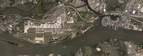
In recent years, more frequent and more intense storms have hit, raising red flags about climate change throughout the region. Hurricane Floyd in 1999 and Sandy in 2012 really drove home the point. When a severe thunderstorm hit PHL eight years ago, it knocked out pumps, cut off power in one terminal and caused flight cancellations.
 Chief Executive Officer Rochelle “Chellie” Cameron notes that PHL is actively working to combat the effects of climate change and sea level rise. More specifically, the airport’s current master plan update will outline a 10-year vision to protect its terminals, roadways and airfields.
Efforts will center on taking action now, before sea levels potentially reach damaging heights. Key plans include incorporating various responses into master planning as well as identifying and preparing critical infrastructure needs in the shorter term. PHL also has conducted comprehensive studies on the threat and associated responses with input from airlines, the federal government and local stakeholders.
In addition, the airport commissioned VHB to perform a Climate Adaptation and Resiliency Plan and a Climate Vulnerability Assessment, which assessed vulnerabilities in various sea-level rise scenarios and recommended that Philadelphia’s Division of Aviation, which owns and operates PHL, continue its climate resiliency planning and preparedness efforts as part of master planning at the airport.
Florence Brown, director of communications for the Division of Aviation, reports that there are also a variety of projects in conceptual evaluation, design and construction. Smaller projects range in price from $50,000 to $200,000, while larger projects could potentially cost millions of dollars.
The more significant point is that those initiatives are setting the climate change bar for PHL. “We are incorporating appropriate design standards to address climate change, which will be implemented in the construction phase of upcoming projects,” Brown explains.
 Ray Scheinfeld, PHL’s Planning and Environmental Services manager, reports that the airport has identified and is incorporating several critical infrastructure components that will need to be protected to allow the most rapid return to normal operations after an event. They include:
- constructing flood barriers at electrical supply feed locations and substations;
- providing redundant IT feeds, computer centers and backup communication systems located both on and off site;
- upgrading climate control systems for airport buildings and incorporating rapidly employable temporary climate control replacement systems; and
- installing properly designed weather-resistant airfield lighting and communications systems.
In still other steps, the airport is enhancing building structures for existing and future facilities, to prevent extreme weather-induced failures. It is also specifying airfield construction and repair materials that can resist extreme heat, cold and pressure, as well stand up to abrasion during cleaning and plowing.
For Scheinfeld, the most challenging aspect is determining what extent and timing of sea level rise/climate change to use for engineering decisions. “The current predictions have a wide range, which makes the selection of endpoint conditions more difficult,” he comments.
Such multi-pronged initiatives do not come easy for any airport, and ongoing collaboration and research are informing PHL’s work. As Scheinfeld explains, the airport has conducted a series of studies to incorporate insights from stakeholders, including the FAA, airlines, the Division of Aviation itself and local police and fire departments. Recommendations stemming from the discussions, include:
- integrating risks related to climate change into training programs, communications protocols, capital planning and asset management;
- evaluating specific flooding vulnerabilities and potential impacts; and
- working with local/regional/state entities to develop climate resilience partnerships and adopt best practices.
Another ongoing initiative that Scheinfeld considers critical is an airport and regional hydrology and hydraulic study. He explains that it will guide responses in the future by allowing a more detailed engineering analysis of vulnerabilities and identifying the best actions to take to protect PHL.
In a broader sense, preparing for sea-level rise and other results of climate change may boil down to being proactive and keeping the issue front and center. As SFO’s Satero sees it, “It’s vitally important to ensure that airports can continue to serve their communities, and deliver all the benefits they provide. That’s why our Shoreline Protection Program is so important, and why we’re moving forward with it.”
As noted, sea-level rise stemming from climate change is taking various forms, and so are airports’ responses to it. But some elements may be useful across the board. As initiatives at SFO and PHL show, plans that are well researched and collaborative can point the way forward—even amid changing times.
| Low-Lying U.S. Airports | |
|
Pacific Coast Oakland Int’l Honolulu Int’l San Francisco Int’l
Gulf Coast Louis Armstrong New Orleans Int’l Ft. Lauderdale-Hollywood Int’l Tampa Int’l |
Atlantic Coast John F. Kennedy Int’l Airport LaGuardia Airport Miami Int’l Newark Liberty Int’l Philadelphia Int’l Ronald Reagan Washington National Fernando Luis Ribas Dominicci Airport |