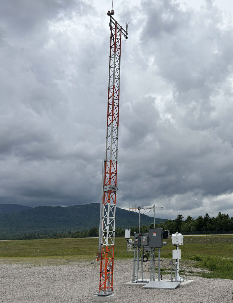
Pilots flying in and out of Bethel Regional Airport (0B1) in Western Maine recently got a major upgrade in the quality of weather information at their disposal. The state’s Department of Transportation and LifeFlight of Maine collaborated to replace the altimeter/visibility system (AWOS-AV), which was often insufficient to support instrument approaches, with a fully FAA-certified Automated Weather Observing System (AWOS IIIP).
A similar upgrade is currently underway at Princeton Municipal Airport (PNN) in the northeast part of the state, and seven more are planned in the next two years.
Although Maine is not the biggest or most rugged state in the U.S., getting around it can be a challenge. A main interstate road facilitates travel north to south, but driving east to west is much trickier. As a result, first responders often access remote areas by plane or helicopter. And they need accurate weather information for safe operations.

facts&figures Project: Strategy: Replace older altimeter/visibility (A/V) weather systems with fully FAA-certified Automated Weather Observing System IIIPs (AWOS IIIPs) that provide real-time data about cloud height/ceiling, wind, temperature & dew point; precipitation identification sensors distinguish among rain, snow & freezing rain Program Manager: Project Partner: Approx. Cost: $450,000/airport Funding: FAA; Maine DOT Prime Consultant: Delta Airport Consultants Key Benefit: AWOS IIIPs connect to the National Airspace System weather network, giving pilots access to real-time weather via cockpit avionics, VHF radio, dial-in telephone & Mesotech’s AWOS Live platform (https://k0b1.awos.live/home) (https://kpnn.awos.live/home) FAA Weather Camera Program: weathercams.faa.gov Initial Scope: Completed Installation: In Process: System Manufacturer for Both: Mesotech Int’l Site Prep for Both: Reed & Reed Installation: Mesotech, with technicians from LifeFlight of Maine trained & certified to support future installations Ongoing Maintenance: LifeFlight of Maine Installations Slated for 2027: Central Maine Airport in Norridgewock; Greenville Municipal Airport; Sugarloaf Regional Airport in Carrabassett Valley System Manufacturer: Mesotech Int’l Site Prep: Phelan Construction Installations Slated for 2028: Eastport Municipal Airport; Newton Field Airport in Jackman; Machias Valley Airport; 1 still to be determined |
Alan Lambert, director of Aviation for Maine Department of Transportation (DOT), says that was one of the main drivers for upgrading airport weather systems across the state. The new AWOS III being installed provide real-time monitoring and reporting of cloud height/ceiling, wind, temperature and dew point; a precipitation identification sensor helps distinguish rain, snow or freezing rain.
LifeFlight of Maine is partnering with the state DOT as it rolls out the new program. John Rolfson, aviation infrastructure engineer with LifeFlight of Maine, says the system’s enhanced capabilities are essential for life-saving missions because accurately assessing extreme cold, wind and icing conditions will help personnel make quick and safe “go/no-go” decisions.
“The information you can get now from the AWOS III units is critical for those operations because the weather here in Maine can be incredibly hard to fly in with the mountains, fog and coastal conditions,” says Lambert, who flew search and rescue missions for the Navy. “The increased IFR capability these systems give us is a huge jump in safety.”
Improvement Needed
The two organizations began coordinating the project about five years ago. FAA’s New England Regional Airport District Office helped secure funding, and Delta Airport Consultants is providing project management at the airport level. To date, FAA has approved nine AWOS III installations throughout the state. Beyond the system already operating at 0B1in Bethel and the one in process at PNN, three additional airports are scheduled to receive upgraded stations next year. Another four installations are slated in 2028. (See Page 48 for specific locations.)
Overall, the state has 35 airports that are part of the National Plan of Integrated Airport Systems (NPIAS), with just three that are N class non-hub primary commercial service facilities. The group as a whole runs the gamut from Maine’s largest airport, Portland International Jetport (PWM), to one of its smallest, Northern Aroostook Regional Airport in Frenchville in the far north part of the state.
The nine airports identified to receive new AWOS III units have used DigiWx AV stations since the early to mid-2000s. “To the average pilot, a weather station is a weather station is a weather station,” says Rolfson. “But the data these stations provide matters, and the different types of stations come with different qualifications.” For instance, only the altimeter and visibility readings provided by DigiWx stations are considered certified FAA data points. “Even though they are equipped with all the other sensors, like wind and temperature and ceiling, you still end up with a METAR [Meteorological Aerodrome Report] viewable at your local airport that is not fully certified.”
When data can’t flow through various FAA channels, it’s difficult for pilots to access through flight planning apps like ForeFlight or Weather Brief. One of the major advantages of the newer AWOS III stations, he explains, is a fully certified METAR that is eligible for more data networks and gets into the hands of pilots for safer and more efficient flight planning. “With the amount of instrument flight rated work that LifeFlight is doing these days, that becomes really critical,” he notes.
Only two companies are FAA-certified to provide AWOS IIIPs: Mesotech International and DBT Transportation Services. Mesotech supplied systems for the program’s first two installations and is now contracted to provide systems for the next three locations as well. When visiting Maine to plan the system conversions, Mesotech Chief Strategy Officer Andrew Kuchel was surprised at how important flying is there. “I didn’t realize how central it is to the state,” he reflects. “There’s a large pilot community, and a lot of areas that are much more easily accessible by an aircraft than almost anything else.”
That is especially true of 15 islands that are part of the state and inhabited year-round. LifeFlight of Maine supports these unique communities with medevac response for emergencies, and ferry service provided by the state DOT connects them to the mainland for routine needs.
The Start of a Statewide Effort
All nine of the initial sites approved by the FAA airport district office to receive AWOS IIIP are uncontrolled airports that serve rural communities. “There are population centers dispersed along the I-95 corridor going north to south in the state. But anybody who has visited Maine will realize very quickly it’s difficult to cross east and west,” says Rolfson. “So, having good weather reporting at those locations is key for the general aviation community and for safe medical evacuation operations.”
Lambert credits the Maine Aeronautical Advisory Board and LifeFlight for providing valuable input on site selection. “We worked with Delta Airport Consultants to submit the nine siting reports to the FAA’s office, and we got all nine approved,” he says, noting that other states haven’t had the same success.
FAA funding for construction and installation was approved for a phased approach, starting with two sites. When selecting those crucial first airports, project planners chose locations that would provide maximum reporting coverage but require minimal site prep such as clearing obstructions. Bethel’s small airfield (0B1), which serves ski resorts in the state’s western mountains, was up first. “They’ve been incredibly supportive bringing this on,” Lambert reports. “It’s a small community, and they really appreciate the upgrade to the airport’s capability that the AWOS III unit will provide.”
He emphasizes that the new technology connects the entire community to a nationwide weather network. “This is not just for aviation, although that’s its primary factor. It’s a benefit for first responders, the town—anybody can dial in.”
PNN, the next location scheduled to come online, is a remote rural airfield in a community that borders a large indigenous reservation and attracts visitors for fly fishing. “It’s a beautiful part of the state, but very hard to reach,” Lambert explains. “The AWOS will provide a huge shot in the arm for their capability.”
Better Data for Better Decision-Making
Another limitation of the current altimeter/visibility systems is that the associated data is only accessible via VHF radio or by accessing the internet; their weather data is not fed into cockpit avionics through ADS-B. “It hasn’t really helped pilots in determining where they’re going and what their plan is going to be because you have to be close enough to an airport that you could almost see the runway before you can pick up the VHF radio,” explains Mesotech’s Kuchel.
 He emphasizes that FAA-certified systems enhance safety by getting important information directly in the hands of pilots. “It’s right on the cockpit screens,” he says. “You don’t have to make a call out with a radio to get that weather data.”
For LifeFlight personnel, having that data at their fingertips helps the medevac team make smart, well-informed decisions early on. “Safety is always the No. 1 decision-making point in deciding to take a flight or not,” Rolfson says. “The challenge is, if we don’t have good, readily available weather data, we might make a flight out to evaluate the weather. But in the air medical world, that can have a lot of consequences for patient care because now we’ve used up a good chunk of time to see if we can get a helicopter or a plane to that location just to have to turn around and come up with a plan B or C.”
Once LifeFlight personnel make a no-go decision for a given flight, they then turn to downstream decisions. For example, if the weather is too poor for helicopter or fixed wing flight, they can immediately initiate a ground response option. Weather data that is more readily accessible will help teams provide patients with the most expedient response possible because they can quickly evaluate options and choose the one that can get them to the designated location fastest.
 Currently, LifeFlight of Maine does a lot of instrument-aided flights with support from DigiWx stations, but their limited FAA-certified data has been a hinderance. “We’ve found ways to utilize that data over the years,” Rolfson says, “but the AWOS III systems absolutely streamlines the process by providing a fully certified METAR, available for all aviation purposes.”
Lambert adds that the weather information is available across the United States, so an out-of-state flight coming into Maine can now get a certified IFR flight plan into Bethel Regional. The AWOS III information also feeds into ForeFlight and other flight planning tools, as well as on the FAA website and Mesotech’s AWOS Live platform for each airport with its cloud-based AWOS III systems.
System Monitoring and Maintenance
After contractor Reed & Reed prepared the construction sites, poured the tower foundations and established electrical service for the first two AWOS III systems, Mesotech and LifeFlight of Maine collaborated on the installations. LifeFlight IT Systems and Aviation Infrastructure Specialist Bill Yates and Rolfson spent two weeks installing the systems at 0B1 and PNN under the direction of Mesotech’s trainer/field technician and ultimately earned their brand-specific factory maintainer certificates with the FAA.
With its personnel now trained and working with Mesotech remotely, LifeFlight of Maine will perform the 2027 AWOS installations and coordinate FAA commissioning for Maine DOT, as well as the ongoing FAA-mandated maintenance for the statewide systems. Mesotech will continue to support the systems with remote monitoring, diagnostics and technical support.
Mesotech’s experience in the military sector includes providing mission-critical weather systems at air bases around the world, often in difficult-to-access locations. As a result, the company has developed ways to monitor the systems remotely, and diagnose/resolve issues quickly, notes Kuchel. “Keeping all those DigiWx systems running has required a lot of elbow grease and miles in cars and planes to get to them,” he says. “Now, we’re working in conjunction with LifeFlight, so that we are coordinating the diagnosis of any issues in advance of John [Rolfson] or his team having to get in a car and go out there.”
Most of the time, he adds, airports don’t discover the DigiWx systems are down until a pilot reports an issue. With remote monitoring for AWOS systems, they’ll know when there’s an issue and can typically prevent being out of commission.
When possible, Mesotech makes sure Rolfson and his team have the appropriate parts in hand so they can resolve the issue in a single trip, rather than going once to diagnose and again to make a repair.
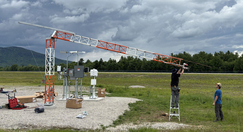
LifeFlight of Maine Infrastructure Engineer John Rolfson and Mesotech Technician Zach Nelson mount and align the ultrasonic wind speed and direction sensor at Bethel Regional.
The current system for installation and maintenance is an extension of previous collaborations between the same key partners. Rolfson says it was back in the early 2000s when LifeFlight of Maine recognized the need to start investing in aviation infrastructure across the state to allow their medevac teams to be more reliable. “It also was a key move just for safer skies,” he adds. “The state really needed it.”
LifeFlight of Maine consequently worked with the state on bond issues to provide the 16 DigiWx stations installed in the mid- to late 2000s, and also took responsibility for their maintenance.
“I’m really thankful for the efforts of all involved and the state of Maine for stepping in to support this next generation of AWOS stations,” Rolfson says. “We’re really proud to continue the work of maintaining them long-term.”
Lambert is similarly excited about the improved resiliency of the new AWOS III systems. “With the old units, five years was a good push if you could even get that much,” he explains. “We’re expecting to double or triple that with the new units, which is a big deal from the funding and maintenance perspective.”
Cameras Keep an Eye on Conditions
AWOS III systems aren’t the only safety enhancement being added. In 2023, LifeFlight of Maine began installing weather cameras at in-state airports to provide a visual check of conditions that weather stations can’t capture—for instance, whether the runway surface has dried after a storm, the status of runway plowing, or if a moose or other wildlife is blocking the runway. As the network grew, LifeFlight connected with FAA’s weather camera program through its third-party host system, which allows organizations to provide imagery to the FAA website. (https://weathercams.faa.gov)
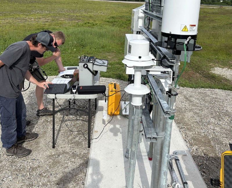
Sensors for the new AWOS IIIP needed to be precisely calibrated.
Weather cameras were pioneered in Alaska as a way to help pilots assess conditions before taking off. The technology resulted in an 85% reduction in aircraft incidents in Alaska and has since spread to other states, including Maine, where LifeFlight of Maine saw an opportunity to address challenges at unstaffed airports and medical landing sites.
 Ultimately, LifeFlight of Maine helped establish one of the country’s more extensive weather camera networks. “It has been instrumental in getting 36 FAA weather cameras installed throughout the state at airports and hospital heliports,” says Lambert. “That’s an incredible record.”
The cameras are intended to complement AWOS stations rather than replace them. Together, the systems give pilots more comprehensive information for go/no-go decisions—measured weather data and visual context about conditions around the runway and approach area. “It’s the coupling of the two,” Lambert emphasizes. “Having both of those systems like we’re getting here in Maine now is fantastic.”
On a broader level, Mesotech has cameras at 50 to 60 of its AWOS III stations around the United States. Typically, they are mounted on 30-foot wind towers to give pilots a view of runway and surface conditions. Kuchel notes that LifeFlight of Maine’s experience helped Mesotech develop its own camera program and work with the FAA to expand the technology.
Benefits Beyond Aviation
Pilots and their passengers aren’t the only beneficiaries of improved weather reporting. First responders, police departments and city councils also rely on accurate local weather forecasting, which they can find expressed in layman’s terms on Mesotech’s website. The AWOS III data also feeds weather forecasting from the National Oceanic and Atmospheric Administration (NOAA) and National Weather Service.
Moreover, having an FAA-certified system helps airports serve as command bases during extreme weather, wildfires or other emergencies. “If the governor needs to show up at a disaster site or even if the president needed to fly in, this technology enables those smaller airports to become a base of operations,” Kuchel says. “The investment the Maine DOT and federal government are putting into this is making this state more ready for those types of events.”
Lambert notes that the systems also are an economic stimulus for airports and their communities, facilitating aircraft traffic that might have otherwise flown elsewhere. “The towns have recognized quickly that this is a big deal for the airport because it gives them the capability to bring in more revenue, which will be a benefit for everybody,” he explains.
Next Steps
As excited as Lambert is about the state’s first two AWOS installations, he’s also looking toward the future. Up next on the list are Central Maine Airport in Norridgewock, Greenville Municipal Airport and Sugarloaf Regional Airport in Carrabassett Valley. The latter two border backcountry lake regions and ski areas that are prone to icing, mountain windshear and lake-effect snow—places where LifeFlight relies on accurate weather data for rescue missions.
“We’ve just started,” Lambert remarks. “This is the just the tip of the spear. We’re going to continue to do this for the next three years, adding more capability across the state. Then, we’ll probably ask the FAA for two or three more and see how that goes.”
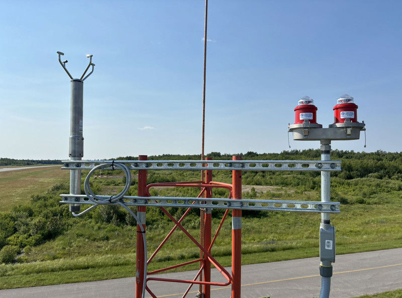
The top of Princeton Municipal’s sensor tower contains obstruction lights (right) and an ultrasonic wind speed and direction sensor (left).
And he likely won’t be the only one asking. AWOS III units and weather cameras are key items airport managers and state DOTS are pushing for in ongoing FAA reauthorization bill discussions. “Those are hot ticket items, and people are letting their congressional delegations know they should be included in the bill,” Lambert reports. “So we’re very happy to have them here in Maine.”
Rolfson agrees. “This is near and dear to the mission of LifeFlight of Maine, but even broader than that,” he says. “I think any investment made into aviation infrastructure across a system like Maine benefits everybody. It improves safety in the sky, and it can only help build and strengthen the aviation community.”
Throughout the process, Kuchel has been impressed by the unique relationship between LifeFlight of Maine and the state DOT. “That partnership has driven all of this,” he says. “In other states, we don’t see this kind of coordination. It’s a great example of the two organizations helping each other out, and that adds great infrastructure for the state.”
Lambert echoes those thoughts. “Hats off to LifeFlight here in Maine because it really started with them, and they’ve made this possible,” he says. “It’s taken awhile to get here, but that makes it even better now.”