Runway 14-32 at Vidalia Regional Airport (VDI) in southeast Georgia has been carrying airplanes since the 1940s. “Some of that concrete out there—probably all of it—is original to World War II,” remarks Airport Manager Billy Ragan.
 Eight decades is a remarkable run for airfield pavement, and it shows. Over the years, the runway has developed cracks, and portions of the top layer are breaking away. The airport doesn’t put its heaviest traffic on 14-32, but the runway is still in use, and a rehabilitation project for it is now out to bid.
The general aviation airport is not a big operation: three full-time employees and one part-timer, 16 T hangars, six box hangars and one community hangar, all full. But from mid-September to mid-June, a private golf club just east of the airfield fills the ramp with serious metal. “We see Global Expresses, Gulfstreams—what I call the heavy iron,” Ragan says. Busy days include upwards of 20 movements. And like many other general aviation airports, VDI has a queue of safety-related projects—clearing obstructions and maintaining airfield pavement—the Transportation Department requires it to complete before funding revenue-generating construction such as new hangars. That makes every project dollar count, and raises a very practical question: Across thousands of individual concrete panels, which ones actually need to be replaced?
Seal or Dig?
| facts&figures
Project: Pavement Analysis Location: Vidalia Regional Airport, in GA Engineering Consultant: Passero Associates Strategy: Slab-by-slab assessment of 80-year-old airfield concrete Timeline: Data about 5,000-ft. runway & associated taxiway collected in 2 days Key Tools: Esri ArcGIS “Field Map” mobile application; GPS-enabled cellphone photo logging Key Benefits: Enhancing airfield safety; tailoring upcoming rehab work to condition of individual slabs Project: Stormwater Study Location: Lake City Gateway Airport, in FL Engineering Consultant: Passero Associates Key Tools: LiDAR-equipped drones; GNSS/GPS base station; indoor inspection drone; proprietary airspace obstruction analysis software Timeline: 800+ acres mapped in 1 day Key Benefits: Documenting water flow; identifying bottlenecks & infrastructure deficiencies (including 50 ft. of underground pipe) |
To determine which portions of the airfield required action, VDI’s longtime engineering consultant, Passero Associates, used technology that fits in a shirt pocket. Engineers arrived with a mobile “Field Map” application, custom built in-house on Esri’s ArcGIS platform and loaded onto ordinary cellphones. Before anyone set foot on the airfield, every pavement area was geo-located and pre-loaded into the app, with standard pavement distress categories available as drop-down menus. AutoCAD Civil 3D linework defining each panel was layered into the map as well.
In the field, the workflow was simple: Walk the runway, photograph each slab, log its condition. Each photo was tagged automatically with its location, and the app updated in real time. A progress bar showed which areas had been assessed, with specific condition data logged. According to Passero, the streamlined process allowed a single engineer to assess the entire 5,000-foot runway and part of its parallel taxiway— 2,147 pavement areas—in just two days.
“Passero was able to take a picture of each individual slab, then analyze that slab: Can we just put a crack seal on top of it, like they crack seal roadways, or do we need to excavate the panel and do a full-depth replacement?” Ragan explains.
The burden on VDI was close to zero. “We really didn’t have to help them at all,” Ragan recalls. “They just checked in with us, had their aviation radios, and we monitored the frequency from inside.” The engineer leading the effort had worked with the airport for four or five years and knew the field. “There was no assistance required from my staff.”
Because traffic at the uncontrolled airfield isn’t nearly as busy as nearby commercial airports, the crew simply pulled off the runway when pilots called in to land, and then went back to work after the aircraft taxied away. Some pavement conditions were visible immediately in the field; the fully compiled analysis followed a couple weeks later. “The engineers were prepared from the moment they accessed the airfield and were able to report specific distress areas by the time they completed the work on the same day,” Ragan reports.
The ultimate payoff was a slab-by-slab treatment map that will benefit the subsequent rehabilitation project through completion. “It helps us identify which slabs we can just seal the cracks, and which slabs have to come out all the way down to the dirt,” Ragan says. “That’s going to help save money, too, because we’re not pulling out every slab.”
800 Acres in a Day
Lake City Gateway Airport (LCQ) in northern Florida had a different issue—water—and management needed a comprehensive stormwater study to address flooding issues in three primary drainage basins. The airfield includes an 8,003-foot primary runway; steady traffic from business jets; a maintenance, repair and overhaul shop; flight schools; and based operations for the state Highway Patrol and Fish and Wildlife Conservation Commission.
Airport Director Ed Bunnell, who has run the field since 2009, has watched Passero (LCQ’s engineering consultant since 2008) steadily fold drones into its routine. After finishing a project such as a new hangar or milling and replacing pavement on the main runway, the firm typically flies the airfield to document completion and update master plan mapping.
For the drainage study, Passero used remotely managed aircraft systems.
“They used LiDAR-equipped drones to scan the airport and to see drainage topology—where the creeks were joined, where the drainage ditches were coming through, and how the water was draining across the airport,” Bunnell explains. If a bottleneck or an unintended dam was choking flow, the data collected by drones showed where to fix it.
The field crew covered more than 800 acres in a single day. “We had a four-person crew using our LiDAR drone and a GNSS/GPS base station to capture elevations and topography on the southern half of the airfield,” says Wyatt Masters, the Passero project engineer and certified drone pilot leading the effort. “Every point of data we collected, from treetops to inside a drainage pipe, was transmitted into our post-processing software for analysis.”
 Flying a drone at the towered airport required coordination, not confrontation. The crew set up behind the FBO, programmed the coordinates to be scanned and worked in short windows cleared with the air traffic control tower. Controllers knew specifically how long Masters and his crew would be flying and at what altitude so they could manage aircraft traffic accordingly.
The resulting dataset fed an engineering report that identified infrastructure deficiencies and recommended removing and replacing a 50-foot section of underground pipe. “Passero did a good job of giving us clear, reliable information without wasting time,” Bunnell says. “Their team worked efficiently, and the LiDAR study saved time in the field while giving us the information we needed to make sound decisions.”
His overall verdict on drone work at LCQ: “Every drone project they’ve done out here has been a very smooth process—no barriers or anything to that effect.”
From Notepad to the Cloud
Bryan Savage, a licensed professional engineer in his 19th year at Passero, has worked in both eras. He spent more than 10 years as a project manager in the firm’s Aviation Department, designing runway extensions, rehab projects, lighting and drainage systems for airports across upstate New York and beyond before moving into his current role as an engineering manager focused on emerging technology.
When FAA Part 107 rules opened the door to commercial drone operations, Savage became the company’s test case. “I was the guinea pig to take us through all that,” he laughs. The punch line wrote itself: Drones are famously restricted around airports. “Here I am thinking that’s pretty much the only place that I want to use a drone, because all my clients are airports.”
 But economics made his efforts worthwhile. “We have to close a runway for two days to get a [traditional] survey. Or, we could come in at night with a drone authorization waiver and LiDAR scan it with no interruption to service,” Savage explains. “If I’m an airport owner, two days of runway closure is just insanity.” A closure ripples out to every tenant on the field, he adds.
For anyone who remembers pavement inspections from past decades, the before-and-after contrast is stark. Previously, a typical pavement management study required two people on site for four or five days, out on the tarmac from 7 a.m. with cameras, notepads, measuring wheels and spray paint, working from an 11×17 plan set with hand-circled photo numbers. In addition to salary costs, there were hotel and ground expenses. Back at the office, the deliverable was a folder of 400 photos and a map key. “If the field guy was really good, he drew an arrow on the legend to let you know which way you were facing,” Savage jokes, recalling frequent confusion about which airfield elements were depicted.
Today, field photos arrive geo-tagged, oriented and sorted into project-specific digital forms, uploaded to the cloud as they are taken. Drone-collected orthomosaic imagery often lands in the firm’s design software within an hour after field personnel return to the office. Savage estimates some survey-related tasks now run 10 to 20 times faster, with overall projects being finished at least twice as fast.
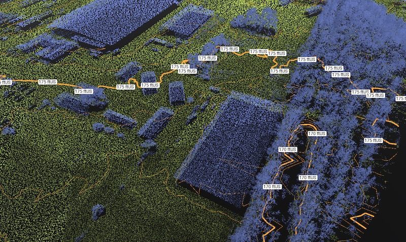
At Lake City Gateway, Passero used drones to map the airport’s water grid.
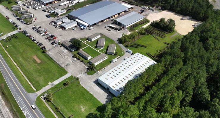
Even so, he is careful to not oversell the utility. “Drones are just really a means of carrying sensors that we’ve been using for years—the same LiDAR that rides on trucks and tow-behind rigs,” Savage points out. “We’re not innovating with a type of technology. We’re just a lot more integrated across those disciplines. So now, the civil engineering and the GIS and the survey, we’re all living in the same programs, and all talking to each other.” This type of integration is how innovation moves forward, even without an individual breakthrough in a specific type of technology, he adds. The ingenuity of integration is the breakthrough in its own right.
When the Answer is No
Operations like those at LCQ and VDI don’t happen casually inside an airport fence. Every flight requires contingency plans with details about flyaways, mechanical failures and contact chains; and the operator must always have a radio whenever a drone is flying. Remote ID, now mandatory, broadcasts the drone’s identity, position, altitude and pilot location, which many airports monitor through drone-awareness software. Ultimately, FAA leaves go/no-go decisions to the local tower personnel, and controllers typically keep drone operations on a short leash. “On the radio, they’ll say things like, ‘You’ve got a minute and a half to be where you are, and then I want you out of there. And then confirm when you are on the ground,’” Savage relates.
Occasionally, the tower simply declines. “Sometimes, it’s too busy and the answer’s just, ‘No.’ The benefits don’t outweigh the risks,” Savage says. The fallback option might be a nighttime LiDAR flight that trades visual imagery for uninterrupted operations, or the crew might use an entirely different method. “It’s a tool,” says Savage. “We’ve learned when it’s not the right tool.”
Regulation remains the drag on the system. Survey-equipment standards for FAA airport data programs still don’t certify drones for some deliverables. Firms must still use traditional aerial platforms to meet specifications for obstruction studies and certain other projects. “Drones are very capable of providing the level of data that they’re looking for,” Savage says. “It’s just the regulation hasn’t caught up.”
The federal ban on new products from Chinese manufacturer DJI stings, too: Of Passero’s roughly 15 drones, 13 are from the company. Savage calls the ban “a rough pill to swallow.”
Indoors, Overhead and Next Door
The airfield isn’t the only place unmanned aircraft systems are going. Savage flies a specialized indoor inspection drone from ReadyVIS Facility (a Passero subsidiary) inside hangars and maintenance facilities to inspect HVAC and fire protection systems, as well as culverts and sewers. Contained in a carbon-fiber crash cage, the unit is specifically built for GPS-denied spaces and is equipped with LiDAR, infrared cameras and flood lighting. “We can essentially be the eyes up above without disturbing anything else,” says Savage. “We’re in and we’re out.” A day’s flight produces 4K video, infrared and LiDAR. A trained machine-learning model pre-inspects the footage before a team of experienced techs and structural engineers review the captured data. Results are streamlined through a custom web app that flags points of interest and assists tracking remediations.
The approach was previously proven in indoor waterparks, where the floor is a pool and erecting scaffolding is a nonstarter. Well-known brands like Great Wolf Resorts and Kalahari Resorts have used drones to inspect mechanical attachments for overhead utilities and infrastructure that would otherwise be very difficult to access.
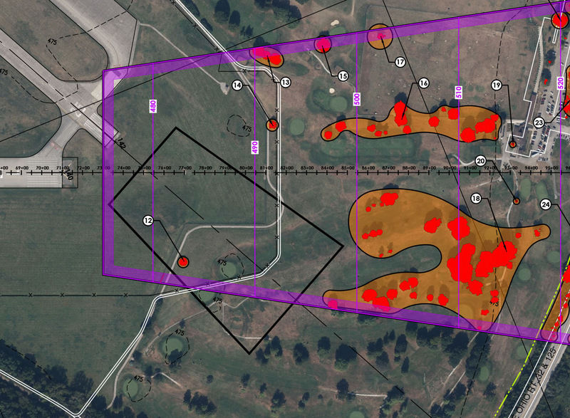
Then there is the airspace itself. Passero built automated tooling that loads an engineered approach surface and ingests hundreds of LiDAR files—80Gb+ point clouds. It also flags every penetration: Red indicates current obstructions and orange identifies trees projected to penetrate within upcoming years, using a standard 13-foot growth buffer. When personnel re-run the analysis against a new surface — say, for proposed nighttime arrivals—the answer is generated instantly.
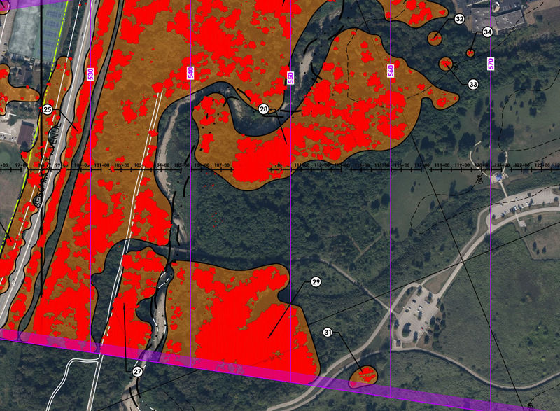
Savage remembers the imprecise alternative: “It used to literally be a dude on the end of the runway with an inclinometer (a telescope with a digital level attached to it) who identified trees optically down the approach slope, then hiked into the woods to flag a trunk.”
The same data can now do double-duty in the community. When an airport asks a homeowner to clear trees, Passero renders the obstruction analysis into a picture of that resident’s property. “I can show them this picture and they can see exactly what we’re talking about,” Savage says. “It beats the alternative, which is just saying, ‘Trust us.’”
Passero is also able to help determine the costs that a land owner may potentially hope to recoup. Knowing the approximate value of the trees to be removed is helpful during the (sometimes heated) discussions an airport might have with neighbors to gain access and permission.
The Race That Matters
Where does it go from here? Savage’s team is experimenting with browser-based 3D models that clients open on an iPad, can be portrayed on augmented reality headsets, and use artificial intelligence. “We’re not necessarily slapping AI on the actual survey data itself, but we’re using it to build tools around the data—to make them more useful, more consumable to our clients,” he explains.
“I only see it getting more easy, more accessible. The equipment will be cheaper and more accurate,” Savage adds. “But it’ll still be a race of who knows how to use the data to actually do things that are useful, versus who’s got the shiniest-looking stuff. And we’re trying to do both.”
Back in Georgia, VDI is leveraging data gathered with a cellphone app to give its World War II concrete another lease on life, one slab at a time. “This project is the first time I’ve had experience with this technology—just taking pictures, uploading them to their software,” says Ragan. “It’s pretty neat. Technology is ever-evolving.”