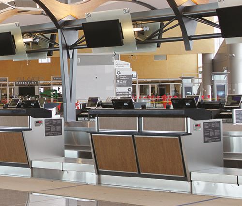
While it’s not the biggest airport in the world—not even Top 10, in fact—Hartsfield-Jackson Atlanta International (ATL) has consistently been the busiest in passenger traffic for about two decades. In 2019 alone, it served more than 100 million travelers. And all those passengers, plus 60,000 or so employees, are tucked neatly into a 6.8 million-square-foot terminal complex.
While it’s not the biggest airport in the world—not even Top 10, in fact—Hartsfield-Jackson Atlanta International (ATL) has consistently been the busiest in passenger traffic for about two decades. In 2019 alone, it served more than 100 million travelers. And all those passengers, plus 60,000 or so employees, are tucked neatly into a 6.8 million-square-foot terminal complex.
After long-time use of geographic information system (GIS) technology for its airside assets, ATL has recently begun focusing attention on leveraging GIS to improve operational efficiencies within the interior spaces of its two terminals and seven concourses. The strategy is to bring together a wide range of data, both static and real-time, to gain a better understanding of assets and facilities, and how they operate in real time.
 ATL engaged Arora Engineers to leverage the power of Esri’s ArcGIS, a mapping and spatial analytics software widely used by the city of Atlanta. Because ATL is owned by the city and part of its system, the airport reaped the benefits of cost sharing associated with the city’s enterprise license agreement. Buying from a company already in the city’s procurement system also helped prevent delays or stumbling blocks during the sourcing process.
|
Project: Geospatial Mapping Location: Hartsfield-Jackson Atlanta Int’l Airport Timeline: Airport selected technology providers in 2019; proof of concept phase in 2021; full implementation pending Cost: Airport is part of bundled enterprise license agreement led by city of Atlanta Lead Consultant: Arora Engineers Inc. Mapping & Spatial Analytics Software: ArcGIS, from Esri Consulting Support: Axim Geospatial Key Benefits: Improved internal wayfinding for vendors & service providers; easier for staff to find/deploy movable assets; faster access to emergency service stations; improved operational efficiency |
 facts&figures
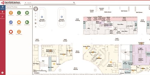
David Wright, the airport’s GIS manager, explains that digital mapping software helps consultants, vendors and service providers work more efficiently at ATL. “We have such a vast array of indoor space, that finding the right location can be difficult,” says Wright. “As we map the elevators, escalators, equipment rooms and assets, this gives anyone working with the airport a tool for indoor wayfinding to better navigate the complexity of our facility.”
The new system also helps airport staff locate and track where various visitors are at any given time.
Mapping From the Inside Out
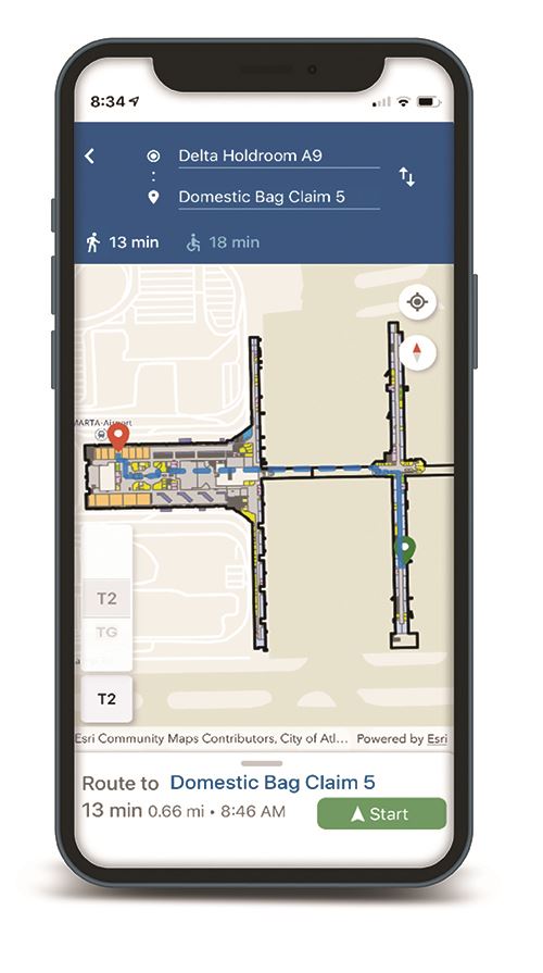
With the proliferation of global positioning systems (GPS) and other digital navigation applications, most people are accustomed to having maps of the world at their fingertips. Following point-to-point directions has become standard for outdoor wayfinding; but navigating indoors requires a different set of technologies. ArcGIS fills that gap, and is what ATL uses to map its interior workings.
“This project is important to us because we have many use cases for GPS navigation and wayfinding for our stakeholders, and there are as many inside as there are outside,” says Wright. “We had tools to leverage that in abundance on the outside and very little on the inside.”
It’s crucial for technicians and equipment vendors to be able to find their way through various levels and constricted areas of the airport, he adds.
The new indoor wayfinding application also helps employees track movable assets, such as wheelchairs, luggage carts and queue management equipment. With various assets moving to and from more than 190 gate areas, having a trail of digital breadcrumbs to follow can save time and mitigate common communication breakdowns.
“Late nights, when the airport is emptied out, different cleaning projects take place and things are moved out of the way,” explains Wright. “In the morning, operations crews arrive and begin to look for these assets, and this gives the team the ability to find them.”
How it Works
Indoor positioning systems, or IPS, include various means of connecting to mobile devices. The primary method ATL is using is iBeacon, a Bluetooth beacon wired into the lighting fixtures. As the airport transitions from fluorescent to LED lighting, fixtures are being outfitted with iBeacons. The technology allows areas to be accurately mapped even in spaces where cellular service can’t reach, Wright explains.
 “It’s sort of like Waze [the community-driven navigational app from Google] for indoors,” says Thomas Tiner, manager of Geospatial Practice Solutions for Arora Engineers. “Users have the ability to select a location they want to go to, like a gate or concession area, and it routes them to that location.”
Esri technology includes an option to use the maps, in a disconnect mode, without a network or cellular connection by downloading this data before entry. Once reconnected, any data added by the user is automatically synchronized.
In addition to helping develop the new mapping system, Arora is training staff on how to curate and maintain the data it produces. The firm also developed a comprehensive data maintenance manual to help the airport team continue on its own.
Terry Bills, Global Transportation Industry manager at Esri, emphasizes the value of gaining a 360-degree view of an airport. Monitoring activities in real time—together with an understanding of infrastructure, assets and how they all interrelate—is critical, he notes.
“That’s what GIS provides: a common operational picture that allows airport staff to not only gain a comprehensive view of the airport, but to also drill into a specific area when needed to understand the location and status of a particular asset,” he explains. “Because of that real-time operational picture, airport managers have greater operational control, which can improve efficiencies and performance.”
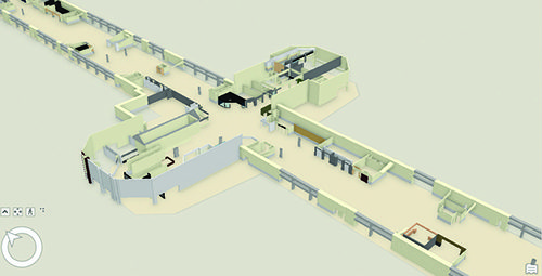
Working with the airport, Arora migrated floor plan data in CAD format to the Esri database. As a team, they determined the points of interest to be created, pinpointing important sites like fire extinguishers, elevators/escalators, automated external defibrillators and more.
Currently, the project is focused on operations, not passengers.
“Benefits from an operational standpoint include situational responses, emergency management, and taking care of the facility,” says Tiner. “For instance, if a pipe bursts, the technology will route maintenance staff directly to that location, creating more efficiency navigating through the airport. If someone is having a heart attack in one of the concourses, emergency services can quickly route to their location, and seconds save lives.”
What’s Next?
Over the last two years, ATL has been slowly building digital maps of its Central Passenger Terminal Complex and Plane Train automated people mover. This year, the team is working on facilities that are not for public access, such as the technology center, maintenance buildings, and back-of-house areas for the rental car center and taxi operations. Space management is extremely important, and web applications are being developed to assist office managers with their respective areas.
“We are still formulating the total benefits, but we can visualize the results,” says Wright. “There will be more productivity gains as staff, contractors and vendors find their way through.”
 According to Bills, almost every major airport in the United States has implemented some sort of GIS technology, and many now consider it a fundamental part of almost all workflows and business processes.
“Just like other technologies, I think it’s important to be clear ahead of time about what your business objectives are, and think through how you want to change and optimize those business processes,” says Bills. “Only then should you embark on any major technology initiative, and GIS certainly falls into that pattern. You don’t want to implement technology just for technology’s sake; that generally doesn’t end well. But in support of clear business and performance improvement goals, then you have a wonderful marriage of people, process and technology.”
Wright and his team at ATL look forward to the possibility of integrating lease management information into the system. Then, airport staff can view lease expiration dates at a glance by using an interactive map versus looking up individual dates and tenants on a spreadsheet. That upgrade is targeted for later this year along with more evaluation to discover other ways the airport, its staff and eventually passengers can leverage GIS services.
“We would very much like to have this technology not just for internal staff, but also for public partners at the airport to be able to utilize in a way that helps them serve their customers,” says Wright. “We see almost an endless supply of benefits from it.”