Every time an aircraft lands on the runway at Hill Air Force Base (HIF) in northern Utah, a mountain of data is captured. More than 80 sensors collect information about pressure, temperature, moisture and other key factors for pavement engineers to parse and dissect. There are even wireless sensors shaped like pebbles mixed into the pavement that transmit data about pressure and slight movements within the pavement system. The goal of this project is to learn more about the way environmental factors and various aircraft affect runway pavements.
Every time an aircraft lands on the runway at Hill Air Force Base (HIF) in northern Utah, a mountain of data is captured. More than 80 sensors collect information about pressure, temperature, moisture and other key factors for pavement engineers to parse and dissect. There are even wireless sensors shaped like pebbles mixed into the pavement that transmit data about pressure and slight movements within the pavement system.
The goal of this project is to learn more about the way environmental factors and various aircraft affect runway pavements. Ultimately, researchers hope to increase the reliability of runway pavements and improve current and future design methods.
The ongoing military project includes a diverse group of partners from several academic institutions and private industry.
|
facts&figures Project: Smart Runway Location: Hill Air Force Base, near Ogden, UT Primary Goals: Increase understanding of aircraft-pavement interaction; enhance reliability of runway pavements; improve future design methods Strategy: Integrate 84 sensors into & on pavement to provide data about pressure, temperature, moisture, movement, etc. Project Cost: $2.1million Timeline: Research proposed in late 2018; sensors installed in June 2019; data will be monitored for at least 4 more years Project Leader: U.S. Army Corps of Engineers, Engineer Research & Development Center Consultant & Software Developer: Woolpert Equipment & Installation Support: Dynatest North America Academic Partners: University of Illinois at Urbana-Champaign; Penn State University at Altoona; Oklahoma State University; Texas A&M; University of Nevada-Reno; etc. |
How it Started
Each year, the U.S. Army Corps of Engineers Engineer Research and Development Center (ERDC) conducts a wide variety of research projects. One of its recent topics of interest was advanced military airfield pavement performance testing and evaluation to support a wide variety of aircraft, environmental scenarios, construction methods and maintenance strategies.
The subject sparked an idea at Woolpert: What if advanced sensors could be installed in active pavement to accurately determine the lifespan of runways? That led a team from the architecture, engineering, geospatial and strategic consulting firm to initiate a collaborative effort with ERDC. The company had worked with ERDC many times before in the development of advanced topographic and bathymetric lidar sensors and algorithms, but this was Woolpert’s first foray into research and development with the pavement group.
“When ERDC reached out to the industry, we thought smart runways would be an interesting topic,” says Ed Copeland, aviation program director for Woolpert. “We teamed up with Dynatest North America and ERDC to figure out what we could do together, and the plan went up to the Hill and Congress for approval.”
 Woolpert proposed using wireless sensors to collect data about aircraft activity, weather and pavement conditions to help airfield owners make better decisions about operations and maintenance. From a safety perspective, the sensors could also be used to monitor and analyze runway incursions. The focus was on monitoring and analyzing both real-time and historical data.
Once the project got the green light, Woolpert, Dynatest North America and ERDC worked with the Air Force Civil Engineer Center to identify several Air Force bases as possible locations to install the sensors and create a smart runway. Hill Air Force Base, the Air Force’s second largest base by population and geography, proved to be their top pick for performing broad, real-world testing.
“Hill Air Force Base has a diverse climate, with hot summers, cold winters and a wide range of temperature cycles,” explains ERDC Senior Scientific Technical Manager Jeb Tingle. “The base also has a diverse mission with a lot of different aircraft, from cargo planes to fighter jets, tankers and fire bombers for the U.S. Forest Service.”
Even commercial aircraft, such as 737s and 747s, use the runway to deliver supplies, he adds. Plus, the Air Force Civil Engineer Center had already programed a routine mill-and-overlay project for the main runway at Hill Air Force Base. That project presented the perfect opportunity for researchers to install sensors while the runway would be closed for other work.

“We presented our project plan to the base that described what we wanted to do, and the command structure was receptive to a new innovative project,” Tingle explains. “They do a lot of aircraft testing, and they’re amenable to supporting critical research activities.”
Airfield Manager Tom Murdoch was instrumental in providing access to the runway and an onsite database with information about aircraft operations. Paul Waite and Branko Vitanov from the base’s civil engineering team were key in coordinating activities between the ERDC/Woolpert/Dynatest team and contractors performing the runway rehabilitation project.
“ERDC conducts research and development for the Department of Defense,” explains Tingle. “We conceived of the concept because we wanted to do real-time research, and our role was to lead the concept, design and implementation. Dynatest North America provided instrumentation support and installation assistance, and Woolpert helped us characterize the paving materials and created the web-based platform that houses the instrumentation data. It’s an online database, if you will, in which the instrumentation response data are uploaded directly from our data acquisition system at Hill Air Force Base.”
SmartRock & Other Sensors
Airfield pavement projects, like airport master plans, are often mapped out in 20-year cycles. Copeland notes that data to prove or disprove the most current hypotheses of pavement lifecycles can help engineer better, more effective plans for the future.
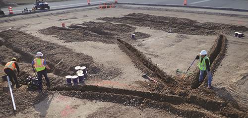
To collect such information at Hill Air Force Base, researchers integrated 84 sensors into the base’s main runway in June 2019. While some sensors sit on the pavement surface, others are buried 10 feet down and at various points in between. The sensors include earth pressure cells, time domain reflectometry moisture/temperature probes, multi-depth deflectometers, bender-element arrays, asphalt strain gauges, laser range finders, infrared thermal sensors and frost depth sensors.
Researchers also receive data from SmartRock, tiny wireless sensors shaped like ordinary pebbles. The high-tech aggregate sits in the ground as part of the pavement; and each time the pavement moves, the SmartRock sensors compute precise measurements and send them to the project database.
Tingle and others involved with the project are encouraged by the information the various sensors are providing. “The smart runway data is being used to monitor the health of the pavement system by tracking changes in the moisture of the different pavement layers, changes in the measured pressures associated with similar aircraft loads and changes in the modulus of the granular layers over time,” explains Tingle. “Matching the pavement response data to the specific aircraft load is allowing ERDC researchers to improve current mechanistic pavement models that will provide an increased understanding of aircraft-pavement interaction and allow better pavement performance predictions. The objective is to use this improved understanding to reduce conservatism in current design methods while improving reliability.”
Monitoring and analyzing real-time and historical data improves situational awareness of overall pavement performance, adds Copeland. “Balancing cost, function and reliability, the smart runway system was designed to increase efficiencies and help to properly allocate operational decisions to improve business intelligence,” he explains.
Big Data
Woolpert was responsible for data acquisition, which was no small task. With sensors providing copious amounts of information about pavement performance, the company was very interested in big data and the applications it could have for this project.
“Once we understood what it was that Jeb [Tingle] and his team of engineers wanted to accomplish and what kind of data they were collecting, we could tailor the data,” Copeland explains.
But collecting the desired data within the constraints of a military installation required finesse.
“Our main challenge was figuring out how to collect the volume of data and information we were getting on a consistent basis without WiFi,” says Copeland. “Being on a military base, they’re not just going to let you plug into their system. So we decided to use cellular technology, connecting it to hardware that could sit outside in a semi-climate-controlled box.”
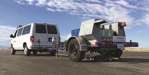
Woolpert and Dynatest engineers designed “data acquisition vaults” to provide safe repositories for short- and long-term storage. Basically, the vaults are rugged outdoor cellular modems for computer and sensor data. Sensors inside the boxes report the internal temperature and transmit that information to the team via a web-based desktop system with query functions that allow web-based access to Department of Defense researchers. Each vault has a heater to keep it warm when temperatures drop and a fan to cool it down when they rise. Copeland likens their shape and function to utility boxes in residential and commercial neighborhoods.
When an aircraft lands on Hill Air Force Base’s runway, it triggers the sensor array that turns on the data acquisition vaults. “We end up with 60,000 to 100,000 data points every time an aircraft lands,” says Copeland.
To manage the large volume of data, Woolpert built a web-hosted app that pulls information from the runway every night. The Woolpert team worked with ERDC engineers to develop automated data processing algorithms to generate graphs and models to illustrate how the pavement responded when each aircraft landed: low peak, high peak, how it rebounded, etc. These data help ensure that the design model is accurate and provide information for engineers to study further. Ultimately, ERDC plans to share the information with the FAA.
Support from Academia
Tingle notes that one of the most challenging parts of initiating the project was the sheer amount of instrumentation it required. Sensors had to be checked, calibrated and tested exhaustively. In addition, the new bender element technology and SmartRock sensors required additional development to support this application. For that phase, ERDC supplemented its own team with graduate students from the University of Illinois and Pennsylvania State University at Altoona.
“There is a lot that goes into the successful implementation of research equipment into an active airfield,” says Tingle. “And it takes a lot of coordination. We couldn’t get in the way of the construction crews laying the pavement; because if they were delayed, they would be required to pay huge fines.”
With sensors generating millions of data points every day, data management and analysis is another other major consideration. Again, ERDC has academic partners to lend a hand.
“Woolpert helped us create algorithms to auto-analyze the information, and Oklahoma State University is helping us parse out the critical data from the raw data and develop specific materials models we used in the pavement reconstruction,” Tingle says. “The University of Illinois is helping with mechanistic pavement response models that will allow us to relay the info to all aircraft and extend the usefulness of this information.”
Every six months, ERDC runs a series of tests on the pavement, and data about every flight in that period is uploaded via cellular connection. The team then shares the data with other trusted academic partners—including Penn State Altoona, which helped design SmartRock—and Oklahoma State. As a military organization, the Army-based ERDC also partners with the Air Force and Navy, and will soon loop in the FAA. The airfield pavement group is a tight-knit community, Tingle remarks.
As the research continues, Copeland reports that the team is getting better at identifying various aircraft as the data rolls in. “We’re using lasers, wheel-spacings and weights to improve our modeling,” he explains. “The idea that we’re thinking about the future of pavements and how to improve via technology is important.
“Now we can use those runway models with confidence,” he reflects. “It is going to change the way the Department of Defense does pavement analysis and design. It’s part of what we’re calling Pavement JEDI2D: Joint Evaluation and Design Integrated (JEDI) software.”